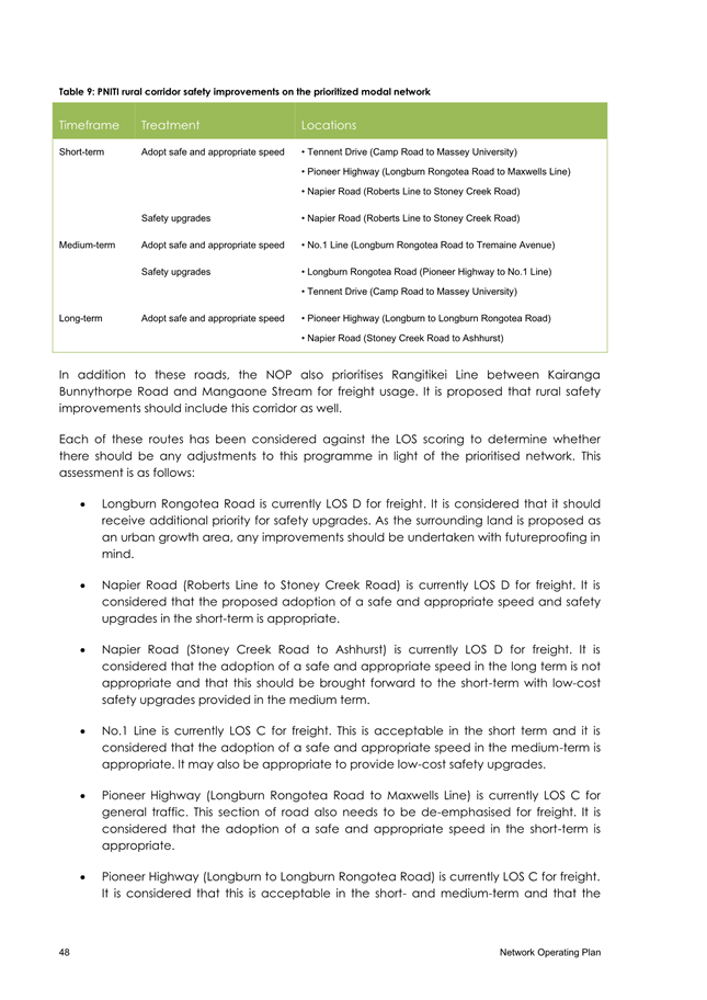
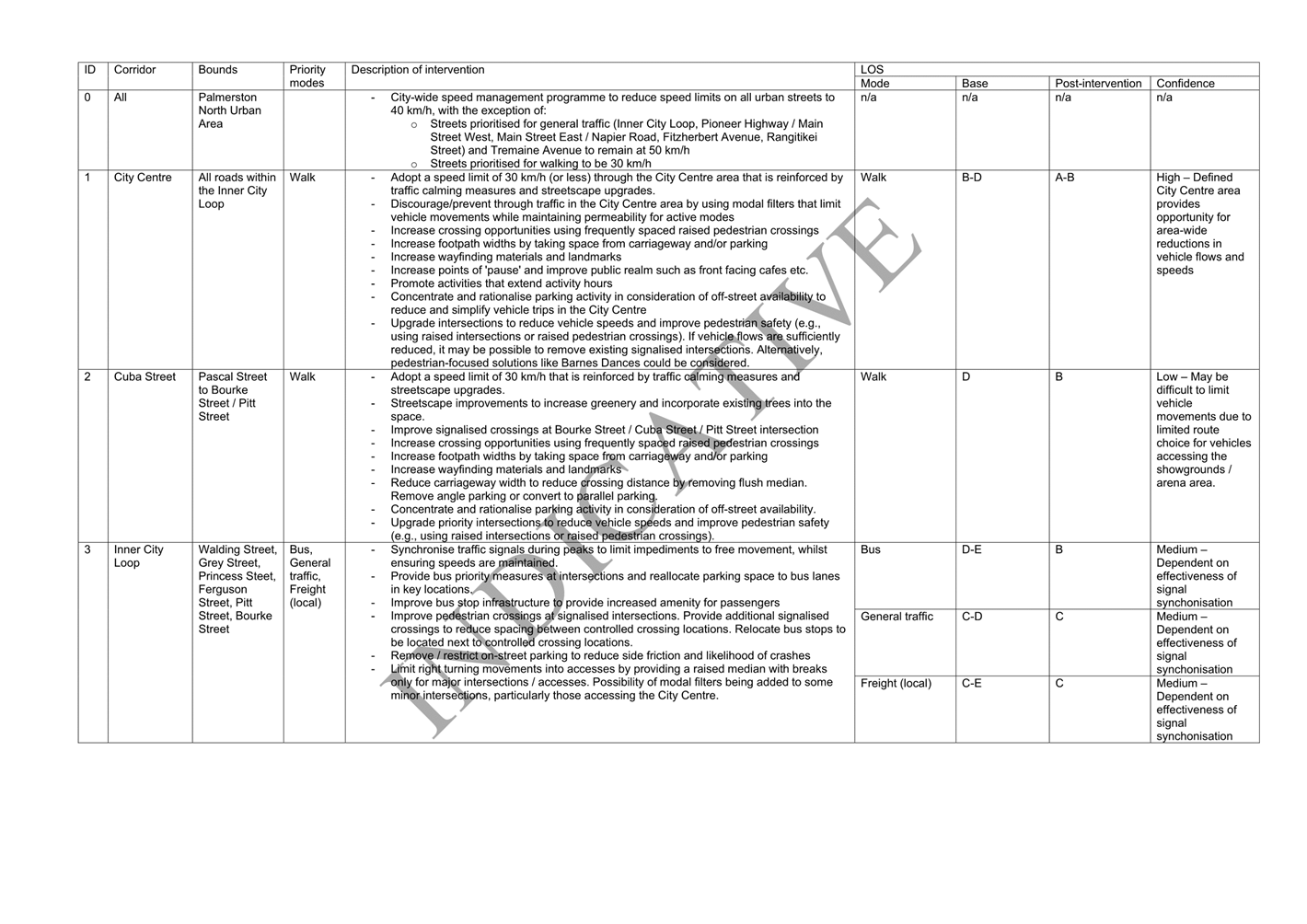
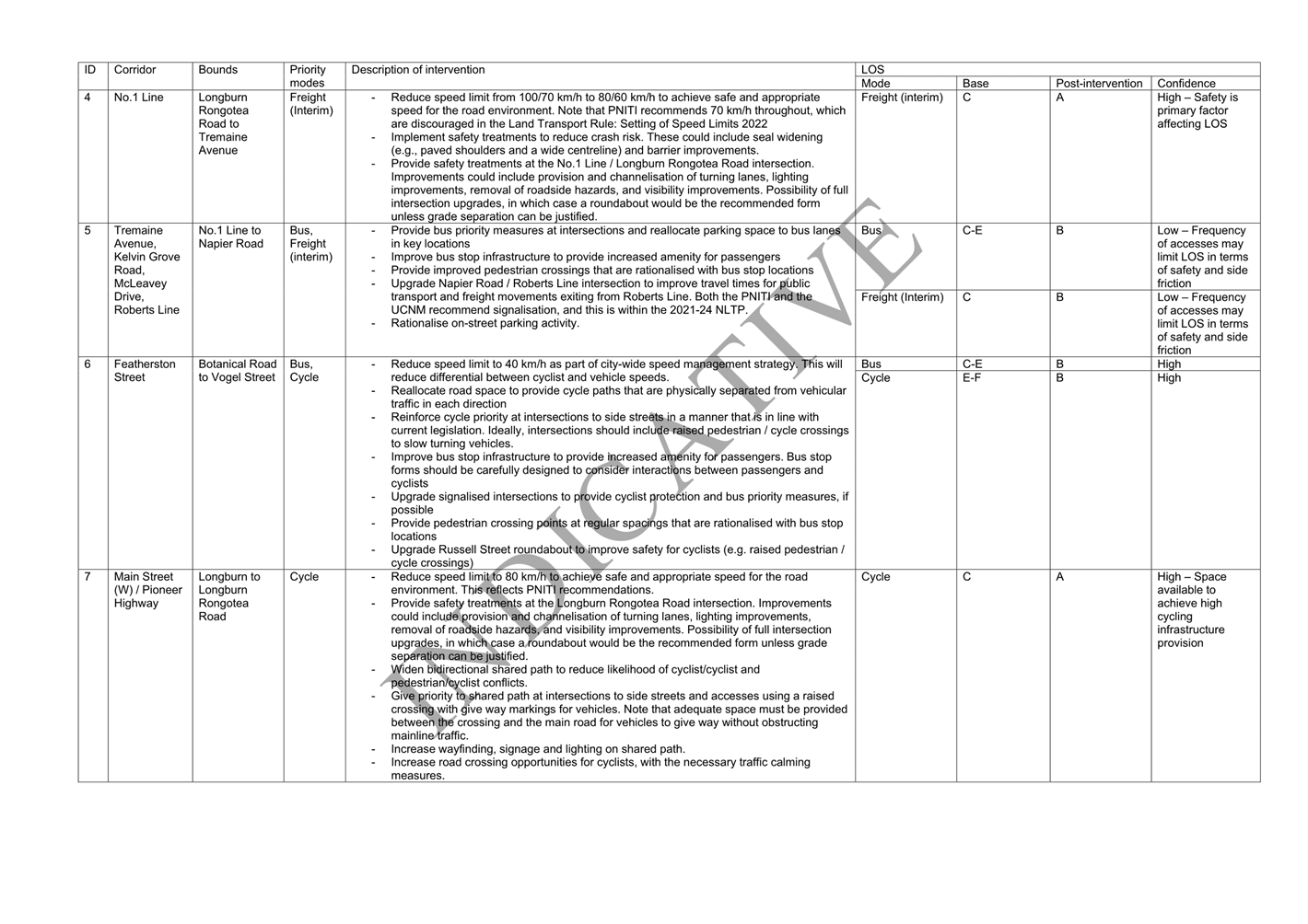
Economic Growth Committee
|
Leonie
Hapeta (Chair)
|
|
William
Wood (Deputy Chair)
|
|
Grant
Smith (The Mayor)
|
|
Mark
Arnott
|
|
Brent
Barrett
|
|
Rachel
Bowen
|
|
Vaughan
Dennison
|
|
Roly
Fitzgerald
|
|
Lorna
Johnson
|
|
Debi
Marshall-Lobb
|
|
Billy
Meehan
|
|
Orphée
Mickalad
|
Economic Growth Committee
MEETING
22 February 2023
Order of Business
1. Apologies
2. Notification
of Additional Items
Pursuant to Sections 46A(7) and
46A(7A) of the Local Government Official Information and Meetings Act 1987, to
receive the Chairperson’s explanation that specified item(s), which do
not appear on the Agenda of this meeting and/or the meeting to be held with the
public excluded, will be discussed.
Any additions in accordance with
Section 46A(7) must be approved by resolution with an explanation as to why
they cannot be delayed until a future meeting.
Any additions in accordance with
Section 46A(7A) may be received or referred to a subsequent meeting for further
discussion. No resolution, decision or recommendation can be made in
respect of a minor item.
3. Declarations
of Interest (if any)
Members are reminded of their duty
to give a general notice of any interest of items to be considered on this
agenda and the need to declare these interests.
4. Public
Comment
To receive comments from members of
the public on matters specified on this Agenda or, if time permits, on other
Committee matters.
(NOTE: If
the Committee wishes to consider or discuss any issue raised that is not
specified on the Agenda, other than to receive the comment made or refer it to
the Chief Executive, then a resolution will need to be made in accordance with
clause 2 above.)
5. Presentation
- Central Economic Development Agency Page 7
Reports
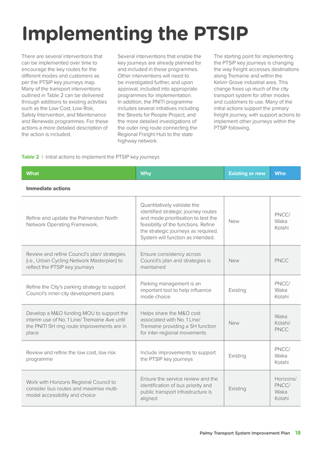
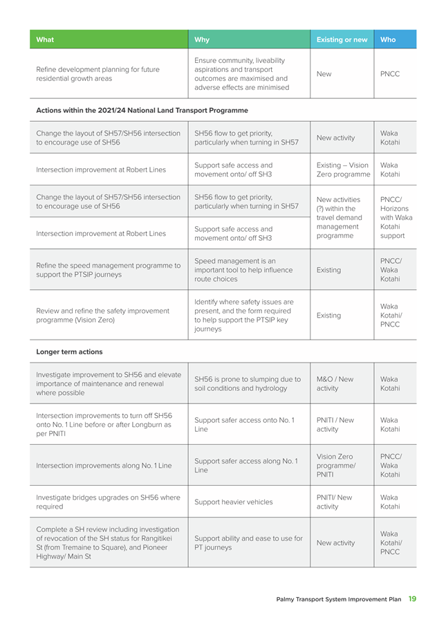
6. Summary
report on the Palmerston North economic structure Page 9
Memorandum, presented by Stacey Bell - City Economist.
7. Palmerston
North Strategic Transport Networks Page 25
Memorandum, presented by David Murphy, Chief Planning
Officer
8. Process
and options to establish and enforce heavy vehicle routes Page 187
Memorandum, presented by David Murphy, Chief Planning
Officer; Peter Ridge, Senior Policy Analyst.
9. Main
Street Cycleway - Permanent Solution Decision Page 199
Report, presented by Hamish Featonby - Group Manager
Transport and Development.
10. Work Schedule -
February 2023 Page 209
11. Exclusion of Public
|
|
To be
moved:
“That the
public be excluded from the following parts of the proceedings of this
meeting listed in the table below.
The general
subject of each matter to be considered while the public is excluded, the
reason for passing this resolution in relation to each matter, and the
specific grounds under Section 48(1) of the Local Government Official
Information and Meetings Act 1987 for the passing of this resolution are as
follows:
|
General subject of each matter to be
considered
|
Reason for passing this resolution in
relation to each matter
|
Ground(s) under Section 48(1) for
passing this resolution
|
|
|
|
|
|
|
|
|
|
This
resolution is made in reliance on Section 48(1)(a) of the Local Government
Official Information and Meetings Act 1987 and the particular interest or
interests protected by Section 6 or Section 7 of that Act which would be
prejudiced by the holding of the whole or the relevant part of the
proceedings of the meeting in public as stated in the above table.
Also that the
persons listed below be permitted to remain after the public has been excluded
for the reasons stated.
[Add Third
Parties], because of their knowledge and ability to assist the
meeting in speaking to their report/s [or other matters as specified] and
answering questions, noting that such person/s will be present at the meeting
only for the items that relate to their respective report/s [or matters as
specified].
|
Presentation
TO: Economic
Growth Committee
MEETING DATE: 22
February 2023
TITLE: Presentation
- Central Economic Development Agency
RECOMMENDATIONTO
Economic Growth Committee
1. That the
Economic Growth Committee receive the presentation for information.
Jerry Sherman, Chief Executive, Central Economic Development
Agency (CEDA) will update the Committee on various CEDA projects.
Attachments
Nil
Memorandum
TO: Economic
Growth Committee
MEETING DATE: 22
February 2023
TITLE: Summary
report on the Palmerston North economic structure
Presented
By: Stacey
Bell - City Economist
APPROVED BY: David
Murphy, Chief Planning Officer
RECOMMENDATION TO Economic Growth Committee
1. That the
Committee receive the report titled ‘Summary report on the Palmerston
North economic structure’ of 22 February 2023 presented to the Economic
Growth Committee.
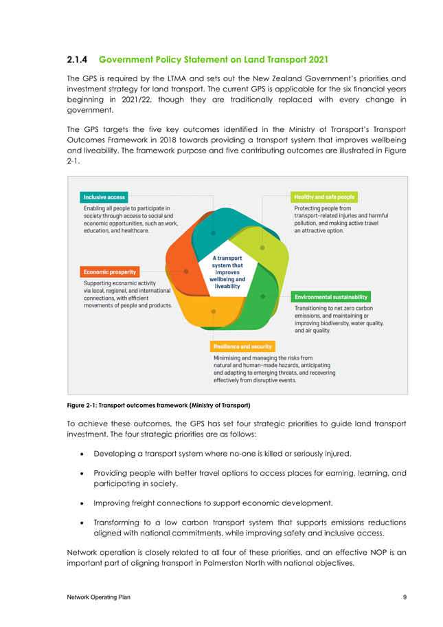
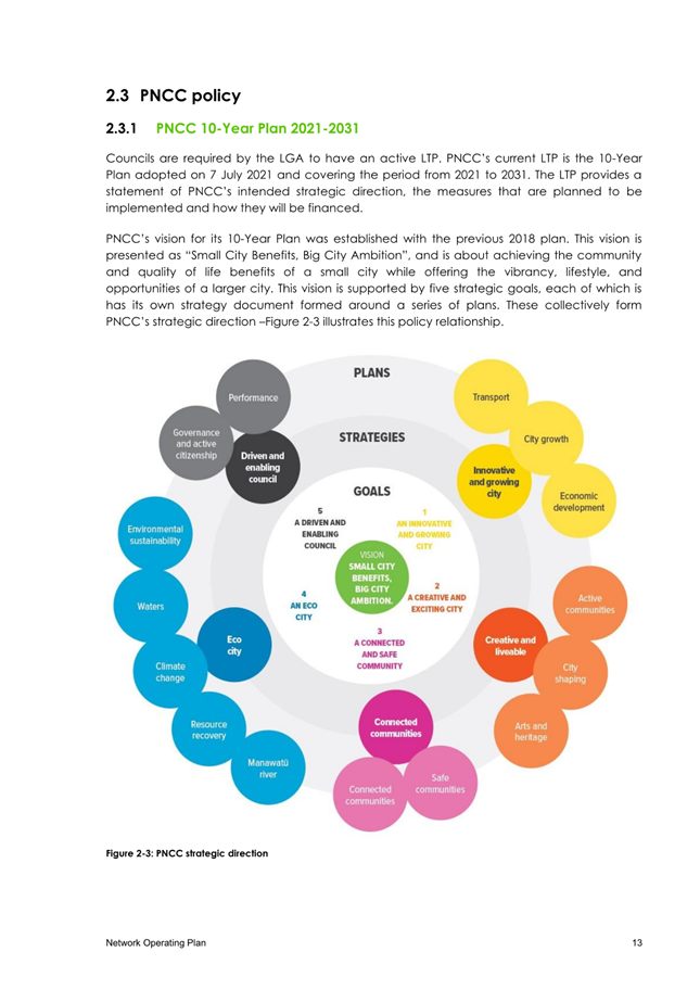
1. Introduction
1.1 This
memorandum presents a summary of the key themes from the Palmerston North
Economic Structure Summary Report 2023 (attached).
1.2 The
analysis of the structure of the Palmerston North economy is based on detailed
economic data from Infometrics and Statistics New Zealand over the period March
2002 to March 2022. This data is the most robust information available on
the structure of local economies across New Zealand.
1.3 The
report summarises the performance of the Palmerston North economy over the
period when COVID-19 was impacting on economic activity.
1.4 Analysis
of the structure of the economy focuses on the sectors which provide employment
to the community. Gross Domestic Product (GDP), employment, and skill
level and employment by occupation, are included within the analysis.
1.4 The
report also summarises annual growth by GDP, employment, and employment by
occupation, as well as 10-year and 20-year growth by sector.
2. THE ECONOMIC STRUCTURE OF THE PALMERSTON NORTH
ECONOMY
2.1 The
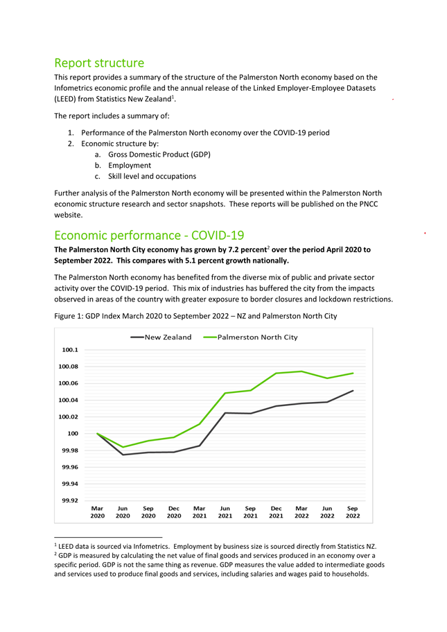
Palmerston North economy performed well relative to the national economy,
growing by 7.2 percent from April 2020 to September 2021. This compares with
5.1 percent growth for New Zealand.
2.2 The
relatively strong performance of the city has been supported by the diverse mix
of public and private sector activity and employment across the economy,
alongside fewer impacts from lockdowns and economic restrictions than the upper
half of the North Island.
2.3 Palmerston
North GDP was estimated at $6.2 billion for the year ended March 2022.
This is an additional $300.2m (+5.1 percent) from the year ended March
2021.
2.4 The
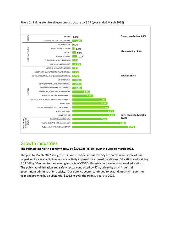
employing sectors of the Palmerston North economy directly generated $5.2b in
GDP (84.6 percent of total GDP) to the Palmerston North economy. A
further 7.9 percent of GDP was generated from owner-occupied property operation
and 7.5 percent from taxes and duties. The analysis of GDP in this report
is based on the GDP generated from employing sectors of the economy.
2.5 The
key findings in the report are:
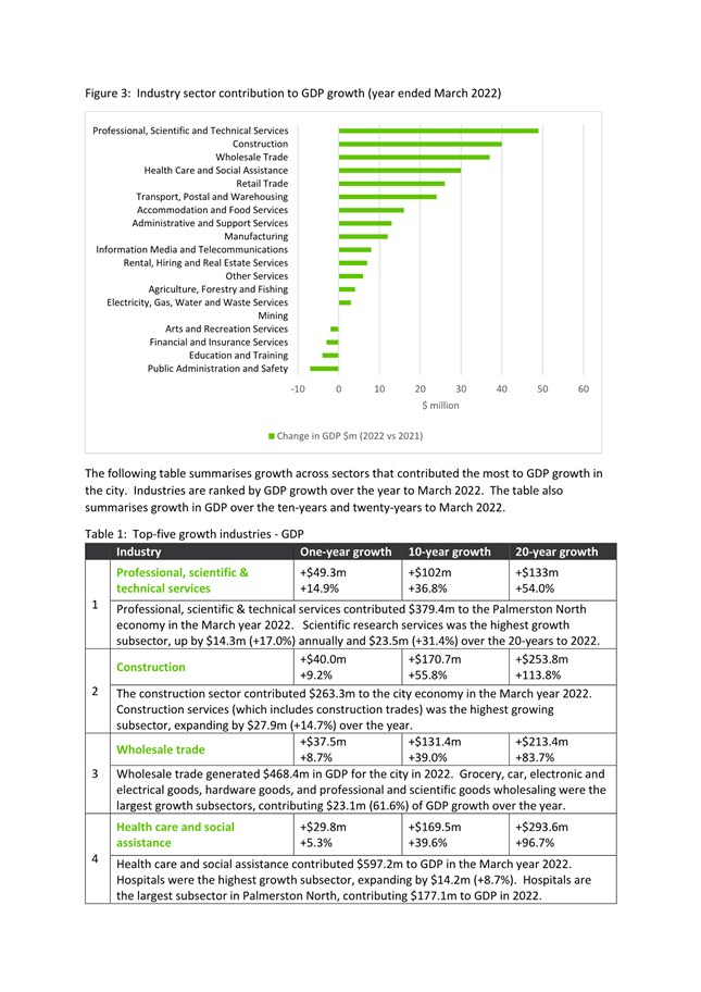
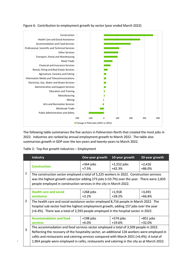
a. The
city economy is buffered by a large and diverse government, health and
education sector, contributing 32.5 percent of GDP and 37.4 percent of total
employment.
b.
One of the largest growth sectors in the economy in the March 2022 year was
professional, scientific and technical services, adding an additional $49.3m to
GDP and generating a further 113 jobs. Scientific research services were
the highest growth subsector, adding an additional $14.3m to GDP and adding 51
jobs.
c. The
construction sector also contributed strongly to growth over the March 2022
year, adding $40.0m to GDP and generating 364 new jobs.
d. Health
care and social assistance are the largest employers in the city while Public
Administration generates the largest share of GDP.
e. Health
care and social assistance was also the largest growth sector over the 20-years
with GDP growing by 293.6m (96.7 percent) and employment by 3,491 jobs (66.8
percent).
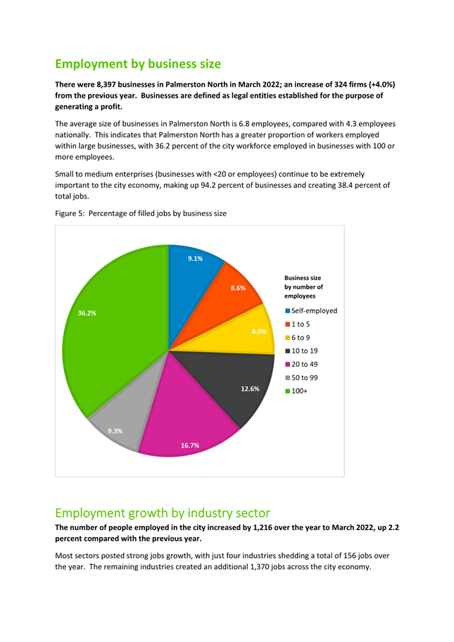
f. There
were 8,396 businesses in the city in March 2022, up by 324 compared with the
previous year (+4.0 percent). Of total workers, 36.2 percent were
employed in businesses with 100+ employees. In contrast, small to medium
enterprises (<20 employees) make up 94.2 percent of businesses and create
38.4 percent of jobs.
g. Of
the total employees in the city, 33.0 percent are employed in
knowledge-intensive industries, compared with 32.8 percent of the New Zealand
workforce. The Palmerston North workforce also has a slightly higher
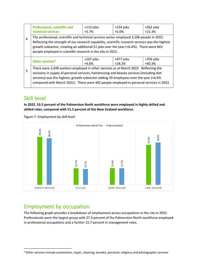
proportion of highly skilled and skilled workers than New Zealand; 53.3 percent
versus 51.5 percent respectively.
h. Professionals
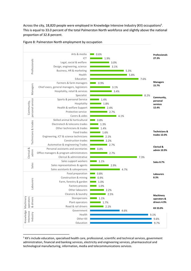
are the largest occupation group in the city, making up 27.3 percent of total
employees. Managers are the second largest group, with 15.7 percent of
the workforce working in management occupations.
i. The
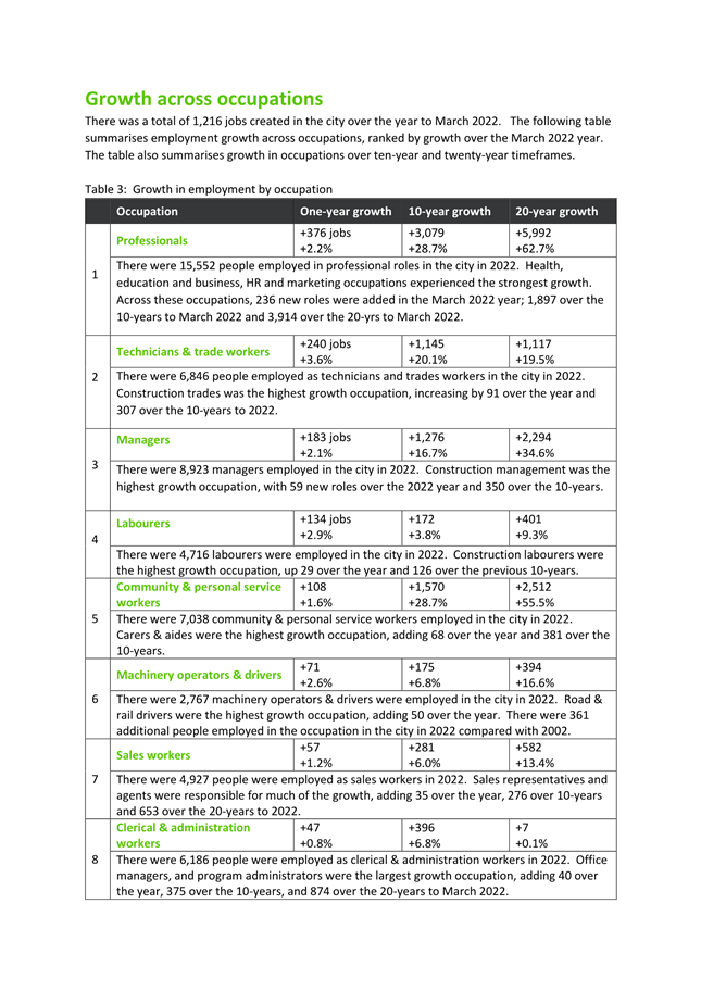
largest growth occupations over the year to March 2022 were professionals
(+376), Technicians and trade workers (+240) and managers (+183).
j. Professional
roles in the city were by far the largest growth occupation over all periods,
adding 3,079 roles over 10-years, and 5,992 over the 20-years to March 2022.
2.6 The
Palmerston North economy has proven resilient through the challenges of the
last few years. The diverse economic base with a solid foundation in
high-value public and private industry, has driven growth in professional and
knowledge-based occupations, supporting jobs and incomes across all layers of
the economy.
3. Compliance and administration
|
Does the Committee have
delegated authority to decide?
If Yes quote relevant clause(s)
from Delegations Manual
|
Yes
|
|
Are the decisions significant?
|
No
|
|
If they are significant do they
affect land or a body of water?
|
No
|
|
Can this decision only be made
through a 10 Year Plan?
|
No
|
|
Does this decision require
consultation through the Special Consultative procedure?
|
No
|
|
Is there funding in the current Annual
Plan for these actions?
|
Yes
|
|
Are the recommendations
inconsistent with any of Council’s policies or plans?
|
No
|
|
The recommendations contribute
to Goal 5: A Driven & Enabling Council
|
|
The recommendations contribute
to the achievement of action/actions in Governance
and Active Citizenship
The action is: Council
decision-makers are provided with quality and timely advice.
|
|
Contribution to strategic
direction and to social, economic, environmental and cultural well-being
|
A sound understanding of the
make-up and contributions of the Palmerston North economy will assist elected
members to make well-informed decisions.
|
|
|
|
Attachments
|
1.
|
Palmerston
North economic structure - summary report ⇩ 
|
|
Memorandum
TO: Economic
Growth Committee
MEETING DATE: 22
February 2023
TITLE: Palmerston
North Strategic Transport Networks
presented
By: Vinuka
Nanayakkara, Senior Transport Planner
APPROVED BY: David
Murphy, Chief Planning Officer
RECOMMENDATION TO
COUNCIL
1. That Council
adopt the Palmerston North Strategic Networks 2023, as detailed in attachments
1-3, as a key strategic document to guide future decision making and investment
prioritisation.
1. purpose
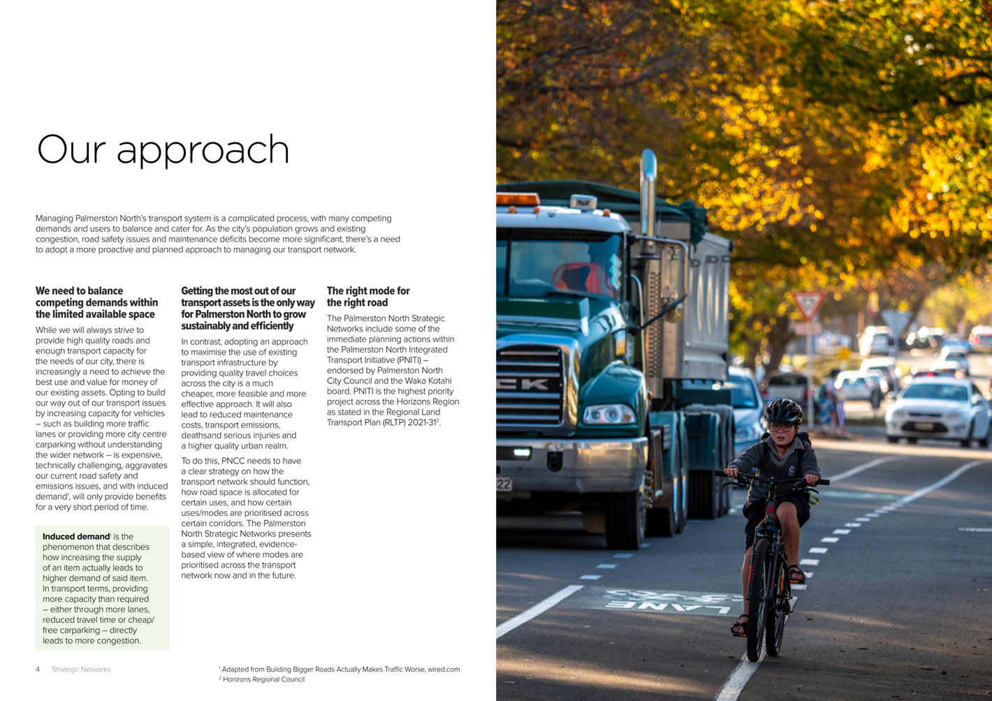
Managing Palmerston
North’s transport system requires a complex and intricate balancing
exercise with many competing demands and users to cater for simultaneously.
As the city’s population
grows and existing congestion, road safety issues and maintenance deficits
become more significant, there’s a need to adopt a more proactive and
planned approach to managing the network in the future – one that reflects
agreed strategic goals and helps resolve competing demands for the limited
space that is available.
While there will always be a
need to provide high quality roads and maintain capacity, there is increasingly
a need to make better use of our existing assets. Adopting an approach to build
out of transport issues by increasing capacity – i.e. widened/more
traffic lanes and more carparking – is expensive, challenging,
exacerbates current road safety and emissions issues, and only provides short-term
benefits due to induced demand.
In contrast, adopting an
approach to maximise the use of existing transport infrastructure by providing
quality travel choices across the city is a much cheaper, more feasible and
more effective approach. It also leads to reduced maintenance costs, decreased
transport emissions, fewer deaths & serious injuries and a better urban
realm.
To do this, Council needs to
have a clear strategy on how the transport network should function, how road
space is allocated for certain uses, and how certain uses/modes are prioritised
across certain corridors. In addition, Council needs to optimise the resources
available to achieve the biggest return on investment for the Palmerston North
community by targeting investments and resource where the largest benefits can
be achieved, otherwise existing resources will be spread thinly across the
wider network for minimal benefit.
The Palmerston North Strategic
Networks presents a simple, integrated, evidence-based and endorsed view of
where modes are prioritised across the transport network across both current
and future states.
The Strategic Networks have
been developed using Waka Kotahi’s Network Operating Plan (NOP) process
– a nationally consistent technical framework that assists in better
management and planning of transport networks, explicitly links transport to
the adjacent land-use, and directly assists in co-funding and co-investment
decision-making.
Elsewhere, NOPs are
traditionally highly operational documents that tend to remain hidden behind
councils’ work programmes and generally have not been accessible to
elected members or the general public. Officers believe there are significant
opportunities to be more transparent and proactive by allowing full access to
Palmerston North’s key strategic transport planning documents –
especially where they present the case for investment for many interfacing and
interdependent projects.
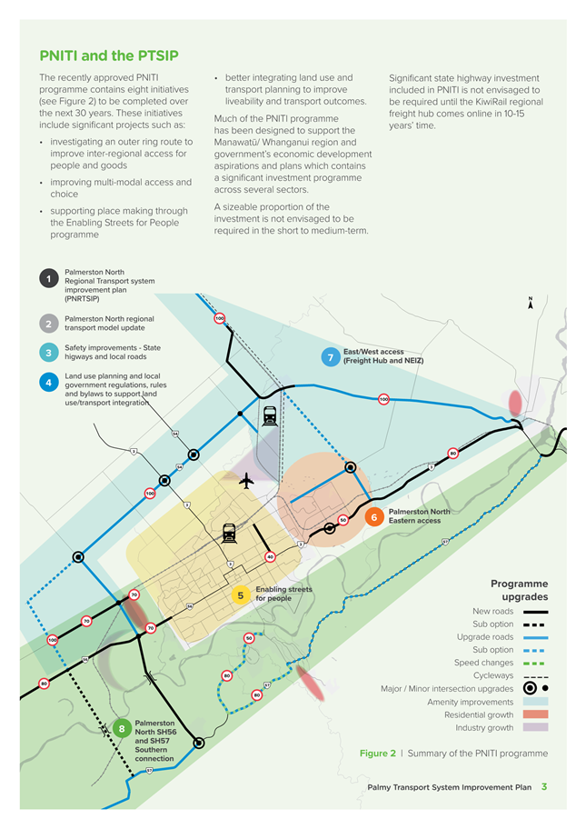
The Palmerston North Strategic
Networks incorporate the immediate planning actions within the Palmerston North
Integrated Transport Initiative (PNITI). PNITI has been endorsed by Palmerston
North City Council and the Waka Kotahi board, and the highest priority project
across the Horizons Region as stated in the Regional Land Transport Plan (RLTP)
2021-31.
2. Context
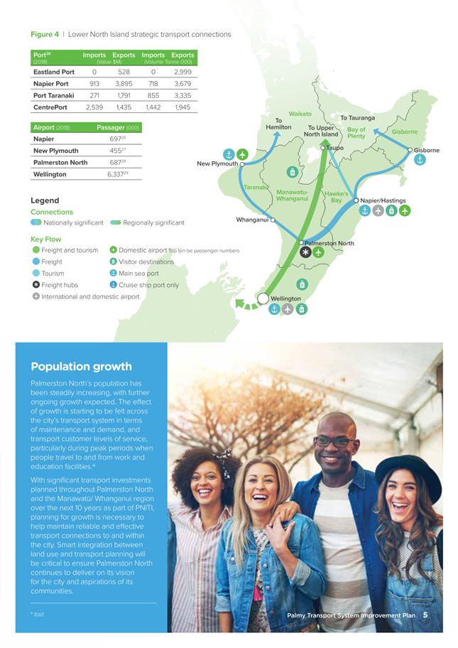
With its central location and connections to several state
highways and rail lines, Palmerston North is unique in providing a transition
between north-south and east-west road and rail movements for New Zealand.
As such, Palmerston North has a critical function in being a
national distribution hub for many freight journeys within the North Island and
particularly the lower and central North Island logistic supply chains. In
addition, Palmerston North has a well-defined city and retail centre which is
supported by significant primary and educational industries.
Palmerston North is an important regional service centre for
the wider Manawatū- Whanganui region with many of the primary industries
located within the peri-urban and rural surrounds of Palmerston North, Horowhenua,
and Manawatū districts. This means the city’s transport system needs
to cater for more than just the people who reside and work in Palmerston North.
Palmerston North’s population has been steadily
increasing, with further ongoing growth expected. The effect of growth is
starting to be felt across the city’s transport network through increased
maintenance, higher traffic volumes and reduced customer levels of service,
particularly during peak periods when people travel to and from work/study.
With significant transport investments planned throughout
Palmerston North and the Manawatū-Whanganui region over the next 10 years
under PNITI, planning for growth is necessary to help maintain reliable and
effective transport connections to and within the city. Integrating our
land-use and transport planning will be critical to ensure Palmerston North
continues to deliver on its vision for the city and aspirations of its
communities.
Approximately 22,000 traffic movements per day occur into
and through the city. These movements are to access jobs, education facilities,
and other social opportunities such as retail, health services, recreation, and
community facilities, along with the several industrial areas located within
and on the outskirts of the city. All these journeys and different modes need
to be considered when planning the transport system.
Based on Council’s 2018 freight demand study, heavy
vehicles permeate through the city’s urban and rural streets to find the
easiest and most convenient route to reach their destinations. Deaths and
serious injuries between active modes and vehicles have been increasing, and
several roads are seeing a lifetime of use within the span of a few years. All
these issues collectively suggest Palmerston North’s roading hierarchy is
not well defined, and conflicts between different modes of travel are abundant
across the city with major consequences to safety, travel choices and road
maintenance expenditure.
The Strategic Networks help clarify the street hierarchy to
better support the movements for all modes across Palmerston North. It also
supports the work of our partners at Horizons Regional Council with the ongoing
work to implement a refreshed public transport system, and Waka Kotahi’s
co-funding and co-investment programme.
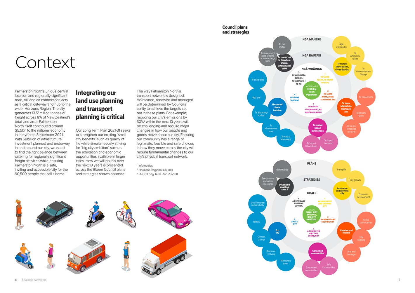
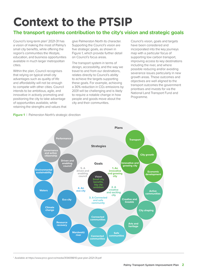
3. Strategic direction
The Long Term Plan 2021-31 seeks to consolidate existing
“small city benefits” such as quality of life and affordability,
while simultaneously achieving “big city benefits” such as the
lifestyle, education, and economic opportunities available in larger cities
across the country.
Therefore, Council intends to be ambitious, agile, and
innovative in actively capitalising on growth opportunities available while
retaining the strengths and values that give Palmerston North its character and
regional appeal. These strategic aims are further refined and outlined across
five strategies and fifteen plans.
The way Palmerston North’s transport network is
designed, maintained, renewed and managed corresponds directly to
Council’s ability to achieve the targets set out in these plans. For
example, achieving a 30% reduction in emissions by 2031 will be challenging and
is likely to require a notable change in how people and goods move about the
city and their communities.
Incentivising “more people [to choose] modes of
transport other than motor vehicles” for more trips also requires
both fundamental shifts in the community psyche and transformational and
explicit changes to the physical network.
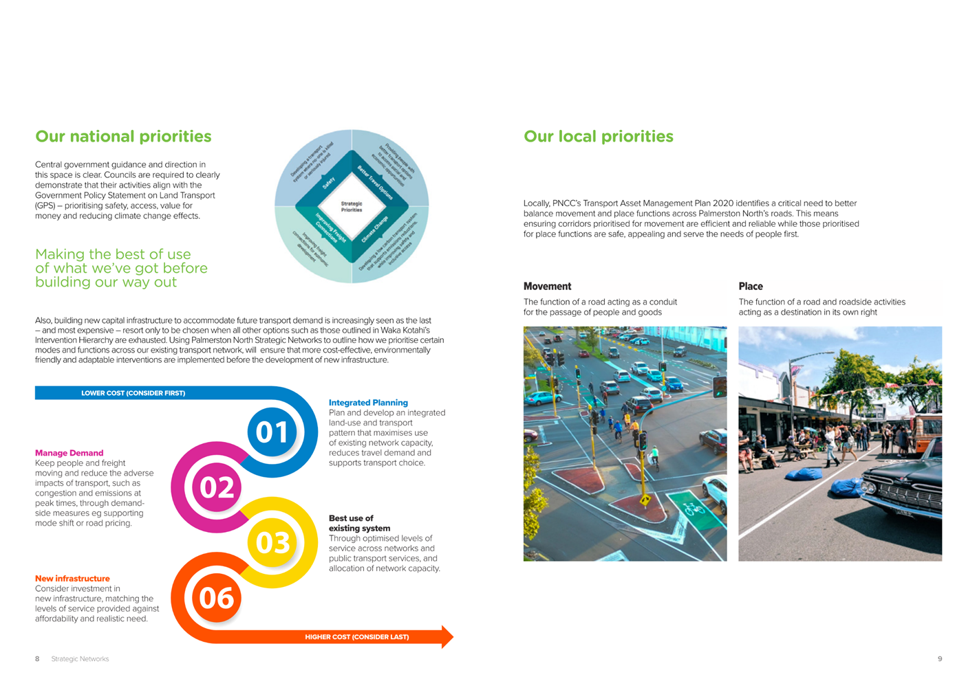
Nationally, central government guidance and direction in
this space is clear. Road Controlling Authorities are required to clearly
demonstrate that their activities align with the Government Policy Statement on
Land Transport (GPS) – prioritising safety, access, value for money and
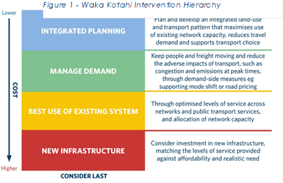
reducing climate change effects. Furthermore, capital new investment is
increasingly seen as a last resort when all other options such as those
outlined in Waka Kotahi’s Intervention Hierarchy (Figure 1) are
exhausted. As the Palmerston North Strategic Networks sets out the
prioritisation of certain modes and functions across existing transport
corridors, it also informs and ensures that integrated planning, demand
management interventions are implemented prior to the development of new
infrastructure.
PNCC Long Term Plan 2021-31
The Palmerston North City Council vision is He iti rā,
he iti pounamu Small city benefits, big city ambition. The Transport plan
primarily contributes to the Palmerston North City Council’s goal of an
Innovative and growing city. The 10-Year Plan level of service for this plan
is:
“Provide an integrated multi-modal transport
network that connects people and goods with destinations in a safe, efficient
and sustainable manner and evolves to meet new transport demands with less
reliance on private motor vehicles.”
The measures of success associated with the Transport Plan
are:
· Less freight
traffic using the urban transport network
· Fewer deaths and
injuries related to use of the transport network
· Increasing walking
and cycling
· Increasing bus
passenger numbers and service satisfaction
· Decreasing carbon emissions
· Decreasing
reliance on private motor vehicles
PNCC’s Transport Asset Management
Plan 2020
Locally, our Transport Asset Management Plan 2020 (AMP)
identifies a critical need to better balance movement and place functions
across Palmerston North’s roads. This means ensuring the corridors
prioritised for movement are efficient and reliable while those prioritised for
place functions are safe, appealing and serve the needs of people first.
Our AMP highlights the following “strategic
responses” – actions needed to address the problems identified and
realise the benefits sought from investment. All of these actions will be
guided by the Strategic Networks:
Safety
Reducing deaths and serious
injuries on the transport network will be achieved through:
· Speed
management. Lower speeds can mitigate the severity of crashes when they do
occur. Target high-risk locations such as around schools
· Deliver
the Safe Network Programme in Palmerston North in conjunction with Waka Kotahi
· Continuously
target safety improvements be it through maintenance interventions or minor
safety upgrades to the transport network
Asset Condition and Performance
Ensuring the transport network
condition continues to meet the desired levels of service will be achieved
through:
· Timely
maintenance and renewal investment that considers the whole of life
implications for the transport assets
· Optimising
road maintenance and renewal activities across the network to achieve the right
balance of investment when assessed against the adopted levels of service,
asset risk, and asset criticality. This may mean increases to existing funding
levels
· Reviewing
levels of service where under or over-delivery may be occurring;
· Ensure
that heavy vehicles are travelling on roads built to carry them
Liveability and Accessibility
Improving liveability and
accessibility through changes to the transport network will be achieved
through:
· Delivering
the Roads and Streets Framework. Use this and the One Network Framework (a
nationally consistent road classification standard) to inform the management of
the transport network
· Recognise
the importance of Place on the Transport network. Ensure that investment
supports this
· Multi-modal
network optimisation to identify and make improvements to walking, cycling and
public transport networks
· Disincentivise
private vehicle use by prioritising active and public transport modes over
vehicles and car parking
· Make
it more difficult for certain vehicles to travel certain routes through the
city. Encourage the right vehicles onto the right roads
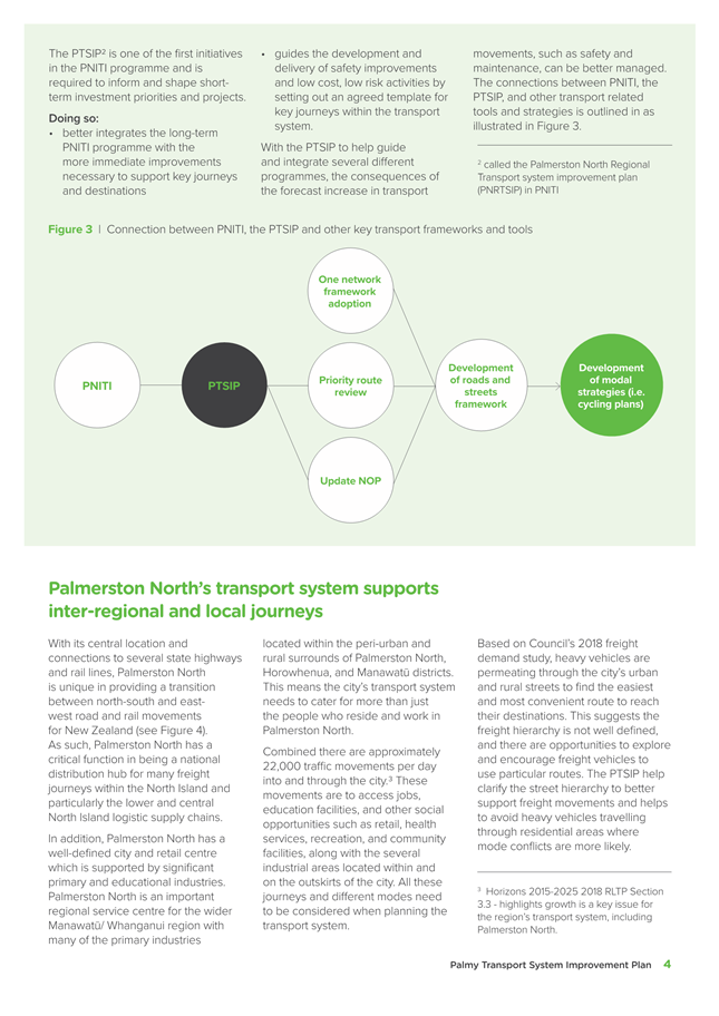
Where This Fits
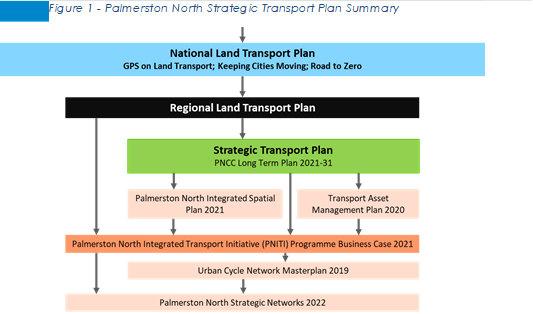
Figure 2 outlines the strategic
links between this piece of work and interrelated strategic documents and
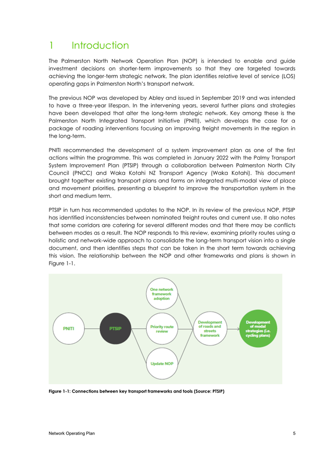
plans. The Strategic Networks is an accumulation of a number of upstream works,
including the PTSIP (1st action in PNITI) and the NOP (Waka Kotahi
requirement). The Strategic Networks also seek to daylight traditionally
internal-facing technical documents in the interests of transparency and
accountability.


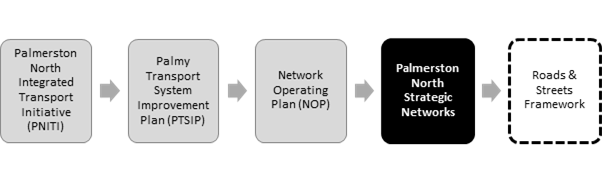
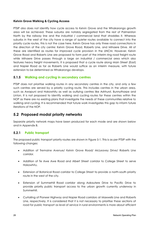
Figure 2 - Where the Strategic Networks fit within council's
work programme
The Strategic Networks will be
a primary input into the development of the Roads and Streets Framework –
an action within the Strategic Transport Chapter of the current Long Term Plan
which directly responds to the LTP goals of achieving “an integrated
transport network with clear priorities for all users based around place and
movement principles”, a “network [that] supports amenity
outcomes, prioritises active and public transport, and directs freight to the
Regional Freight Ring Road” and to ensure that “street
design is responsive to land-use, place and movement” across
Palmerston North.
4. discussion
All transport modes have key
roles to play in the movement of people and goods across Palmerston North, and
it’s essential that the function of each mode is integrated with other
modes in a pragmatic, cohesive and safe manner to unlock their full potential.
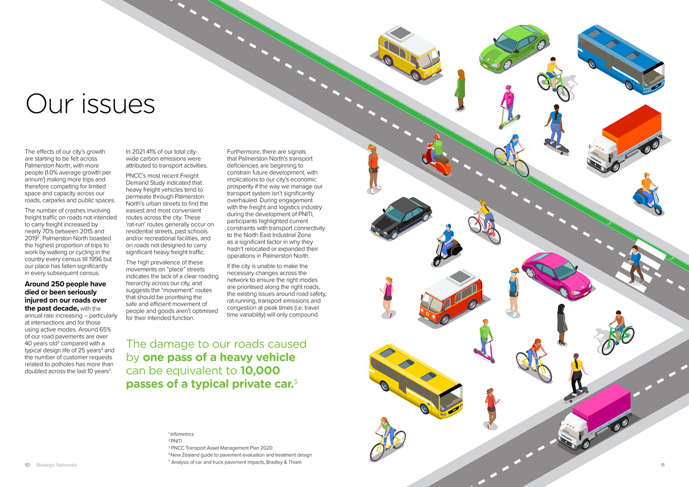
Palmerston North’s highly permeable grid-based roading
network provides many route choices for general traffic and vehicles, but does
so at the expense of safe, reliable and connected routes for those walking,
cycling and using public transport. Heavy freight vehicles past schools,
private vehicles rat-running to avoid busy intersections and buses stopping in
cycle lanes are all examples of how the management of the city’s
transport network has enabled the wrong vehicles to travel on the wrong roads,
sometimes at the wrong times.
Therefore, Council’s vision, goals and targets along
with those from regional and central government have been strongly reflected
across the development of the Strategic Networks with a particular focus on the
following objectives:
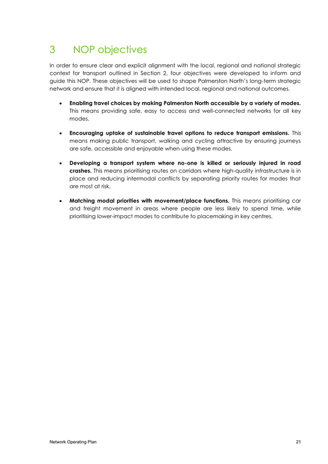
1. Enabling
more travel choices by providing safe, easy to access and well-connected
networks for all modes.
2. Encouraging
uptake of sustainable travel options to reduce transport emissions by making
public transport, walking and cycling appealing, safe, accessible and enjoyable.
3. Developing
a transport system where no-one is killed or seriously injured in road crashes
by prioritising routes on corridors where high-quality infrastructure is in
place and reducing intermodal conflicts by separating priority routes for the
highest risk modes.
4. Matching
modal priorities with place functions by prioritising general traffic and
freights movement where, while prioritising active modes and public transport
in place-based areas.
These objectives are strongly aligned to the central
government transport outcomes set out in the GPS and the Ministry of Transport
Outcomes Framework – both of which set the direction for central
government investment prioritisation via the National Land Transport Fund
(NLTF).
The Palmerston North Strategic
Networks are a summarisation of existing plans and strategies – at
central, regional and local levels – into a single and simple network
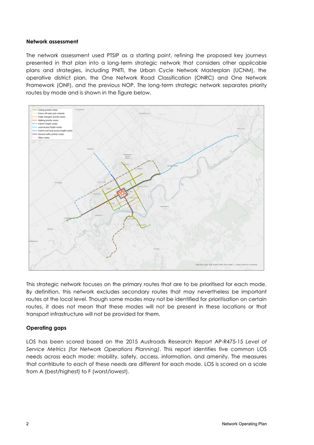
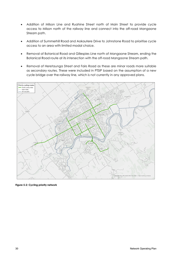
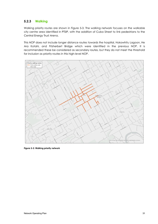
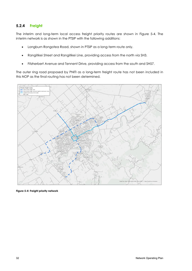
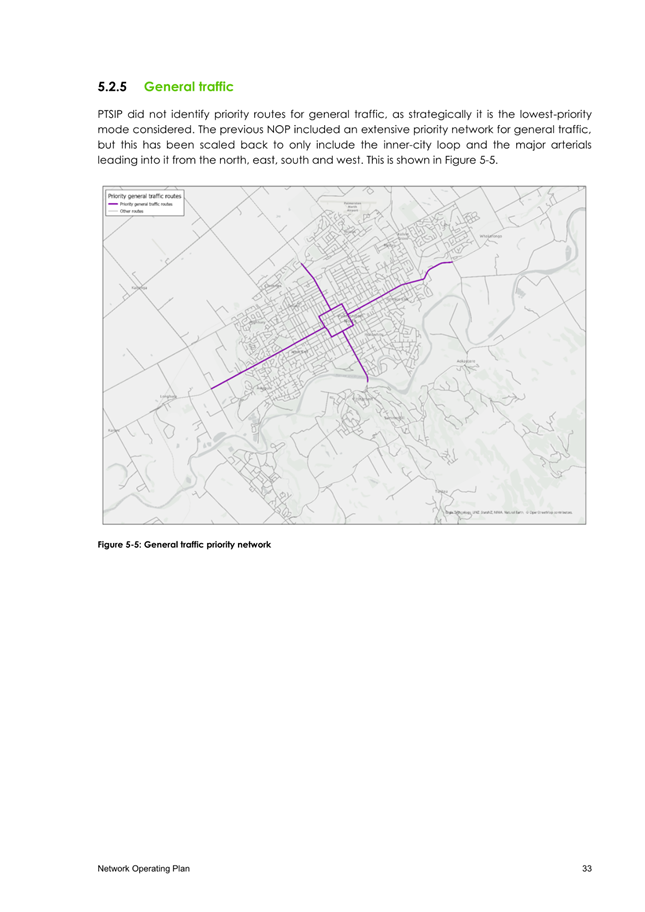
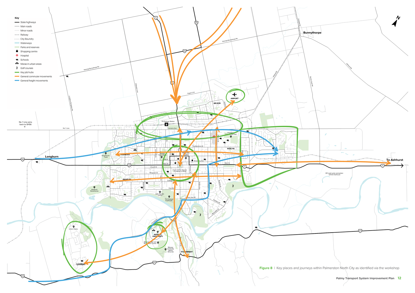
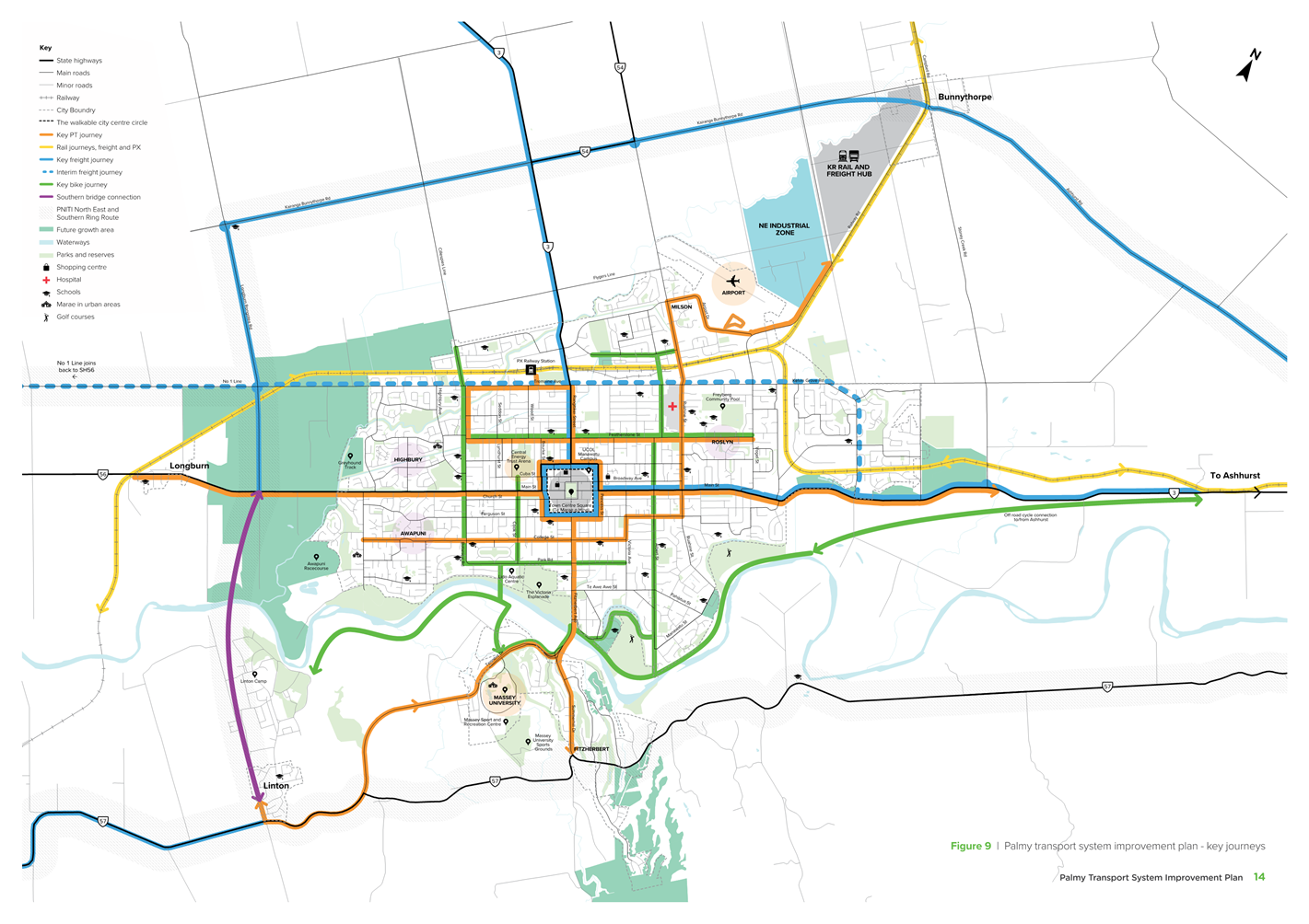
plan as outlined in Figure 3.
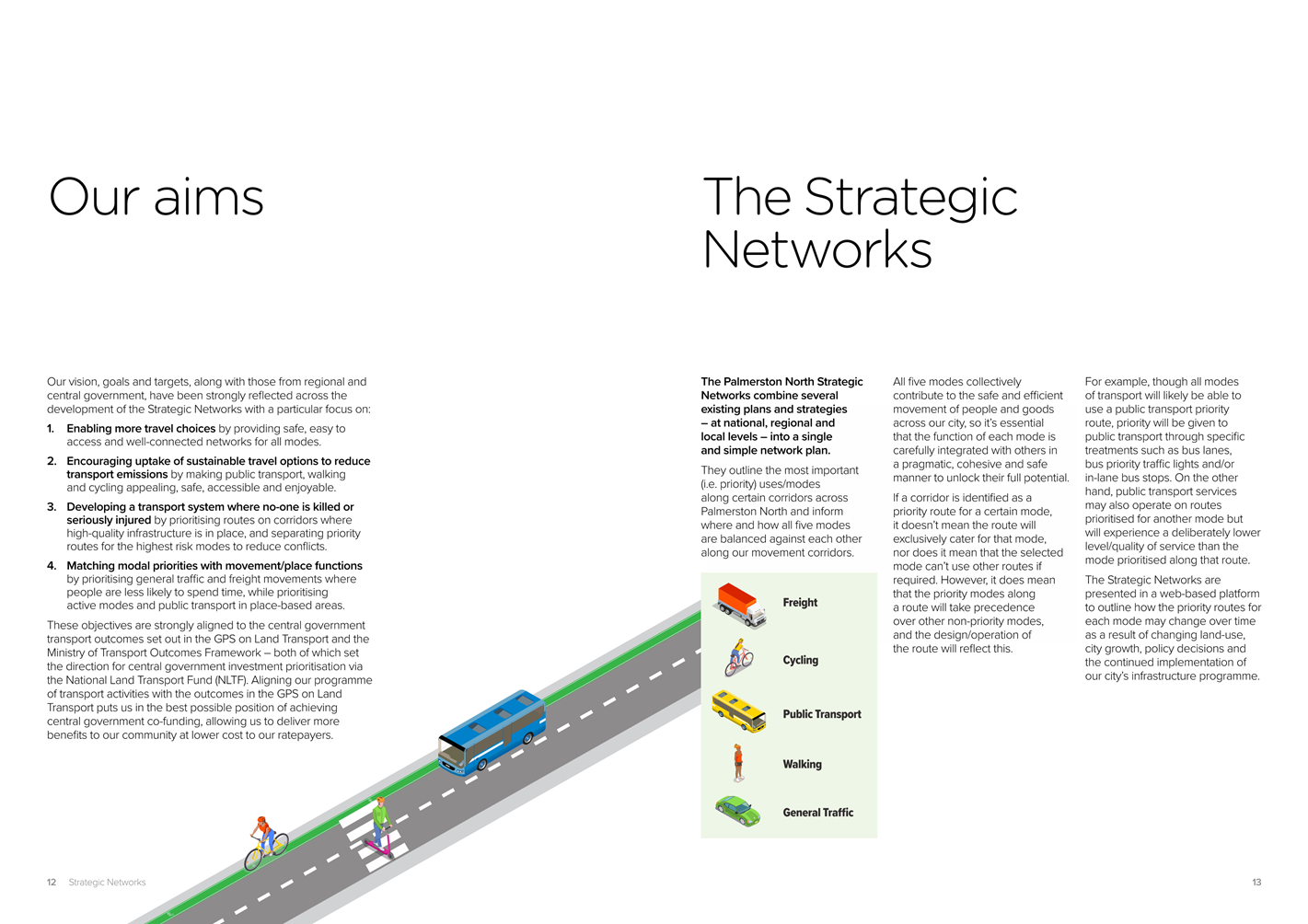
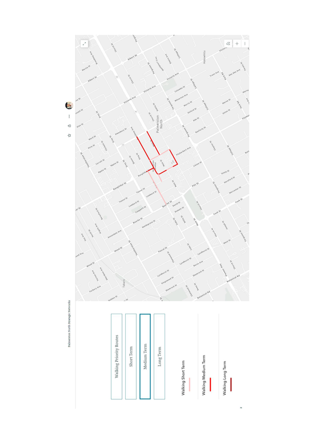
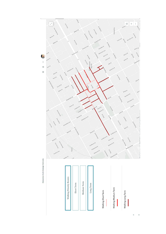
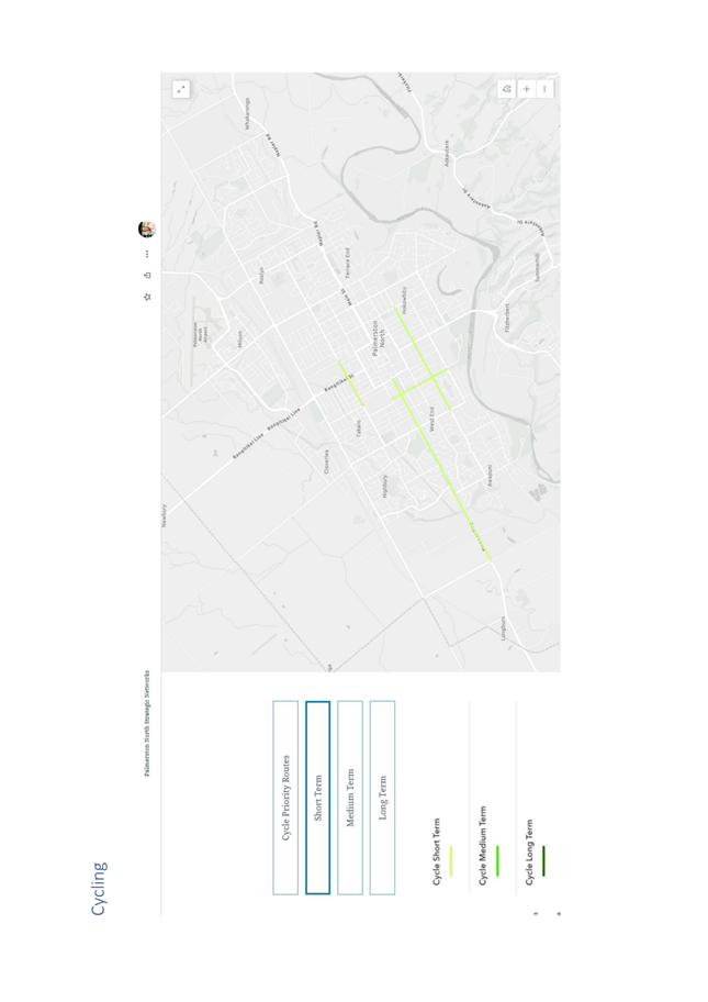
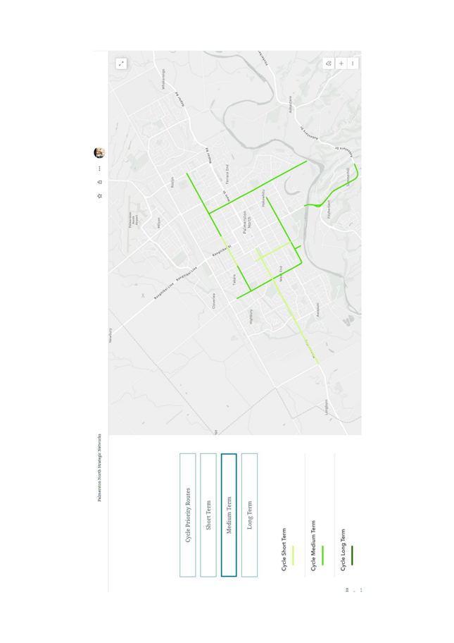
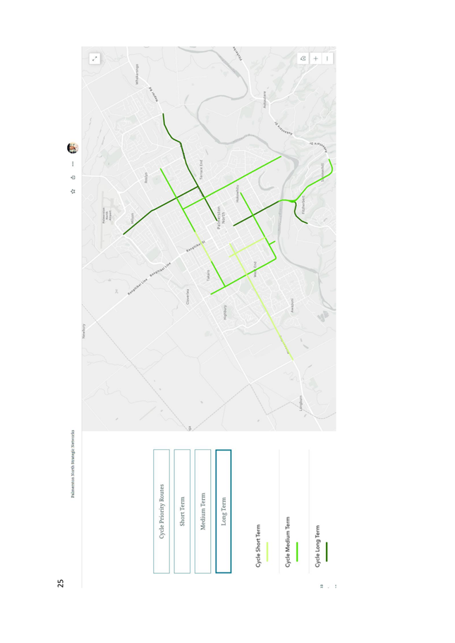
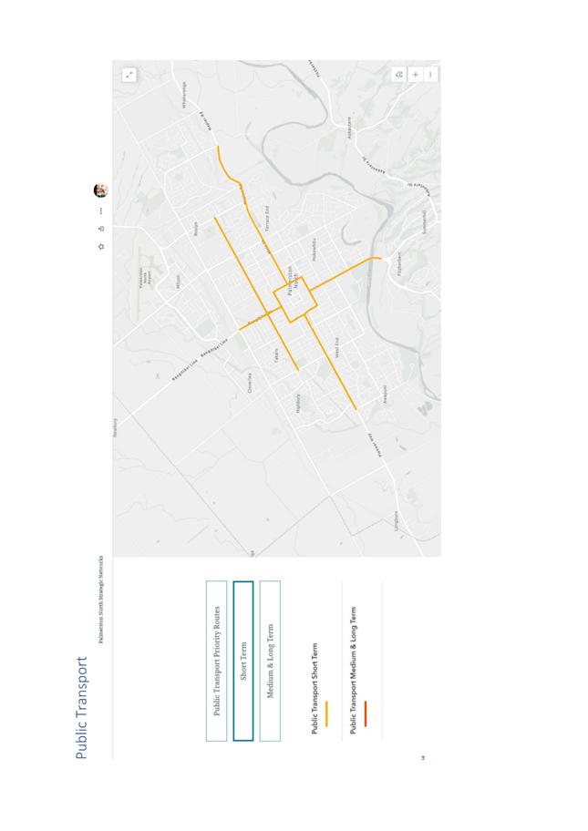
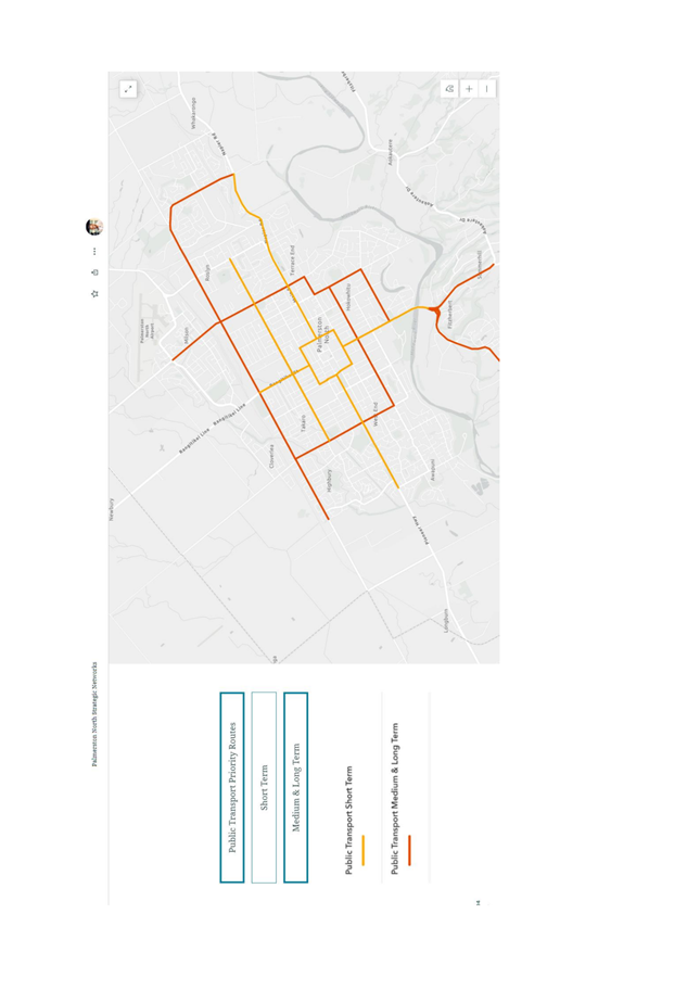
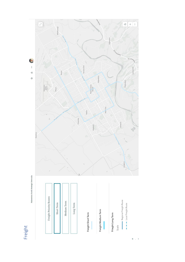
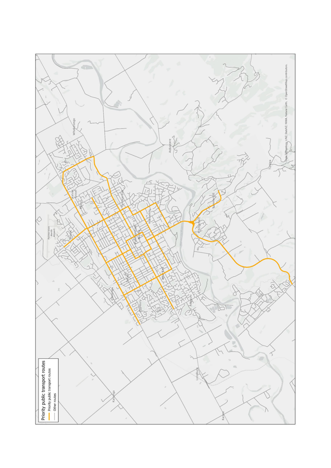
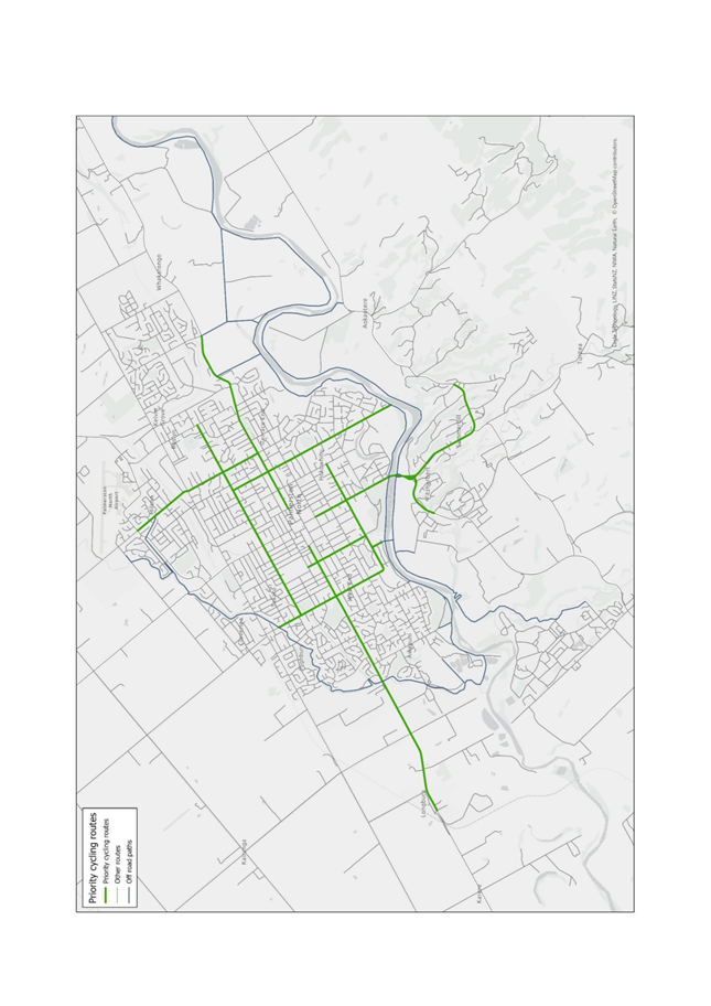
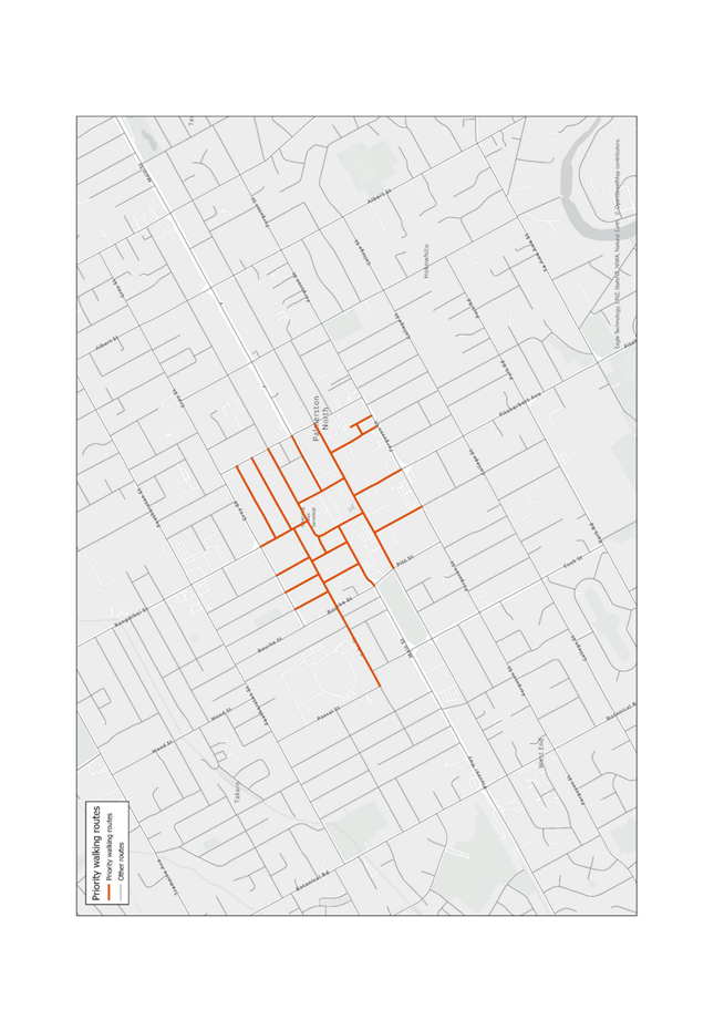
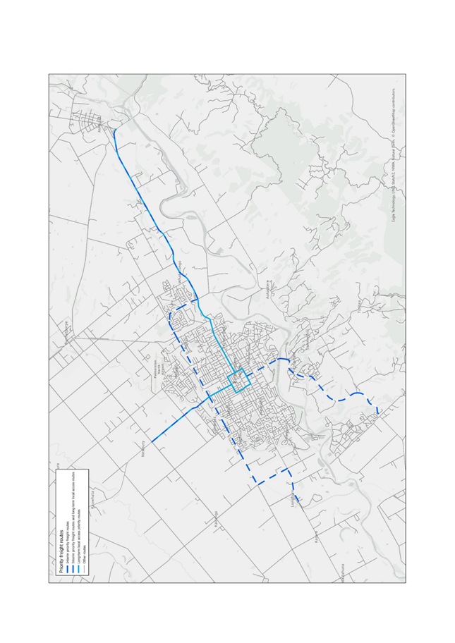
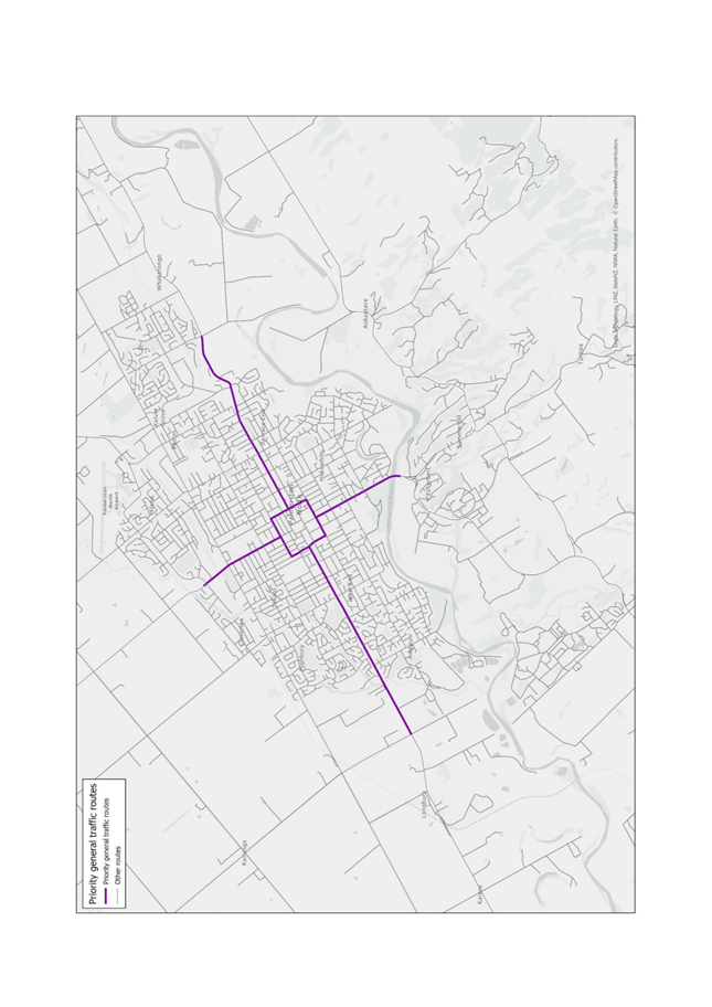
The Strategic Networks outline
the most important (i.e. priority) uses/modes along certain corridors across
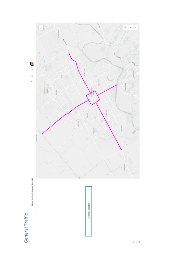
the city for the following modes:
1. Freight
2. Cycling
3. Public Transport
4. Walking
5. General Traffic
The identification of a
priority route for a particular mode does not mean that the route will
exclusively cater for that mode, and neither does it mean that said mode cannot
use other routes if required. However, it does mean that the priority modes
along a route will take precedence over other modes, and the design and
operation of the route will reflect this.
For example, where a route is
identified as a public transport priority route, all other modes of transport
will likely be able to use the route. However, priority will be given to public
transport through the use of location-specific treatments such as bus lanes,
bus priority traffic lights and/or in-lane bus stops (most recently seen within
the Cuba Street redevelopment), meaning the level of service for other modes
will likely reduce. Conversely, public transport services may also operate on
routes prioritised for other modes and will therefore experience a deliberately
lower level of service than the modes prioritised along that route.
Some routes will be identified
as priority routes for multiple modes. In some cases, the existing form and
function of these routes may have engineering constraints that inhibit council
to be able to safely accommodate and provide a high level of service for all
the defined priority modes. Wherever this issue arises across the network, the
Strategic Networks will enable these conflicts to be identified and provides a
basis for further detailed analysis to take place alongside further engagement
between council partners, stakeholders and the wider community.
The Strategic Networks has been
developed using a quantitative, data-driven and nationally consistent approach.
However, it does not replace context-specific and project-specific thinking and
analysis, and neither does it replace public engagement and consultation on
specific projects and interventions. It merely highlights how Council’s
strategic transport context – in addition to the regional and central
government transport priorities – are reflected across Palmerston North.
All projects and interventions for which the Strategic Networks provides
guidance for will have their own technical design, council approval and public
engagement processes.
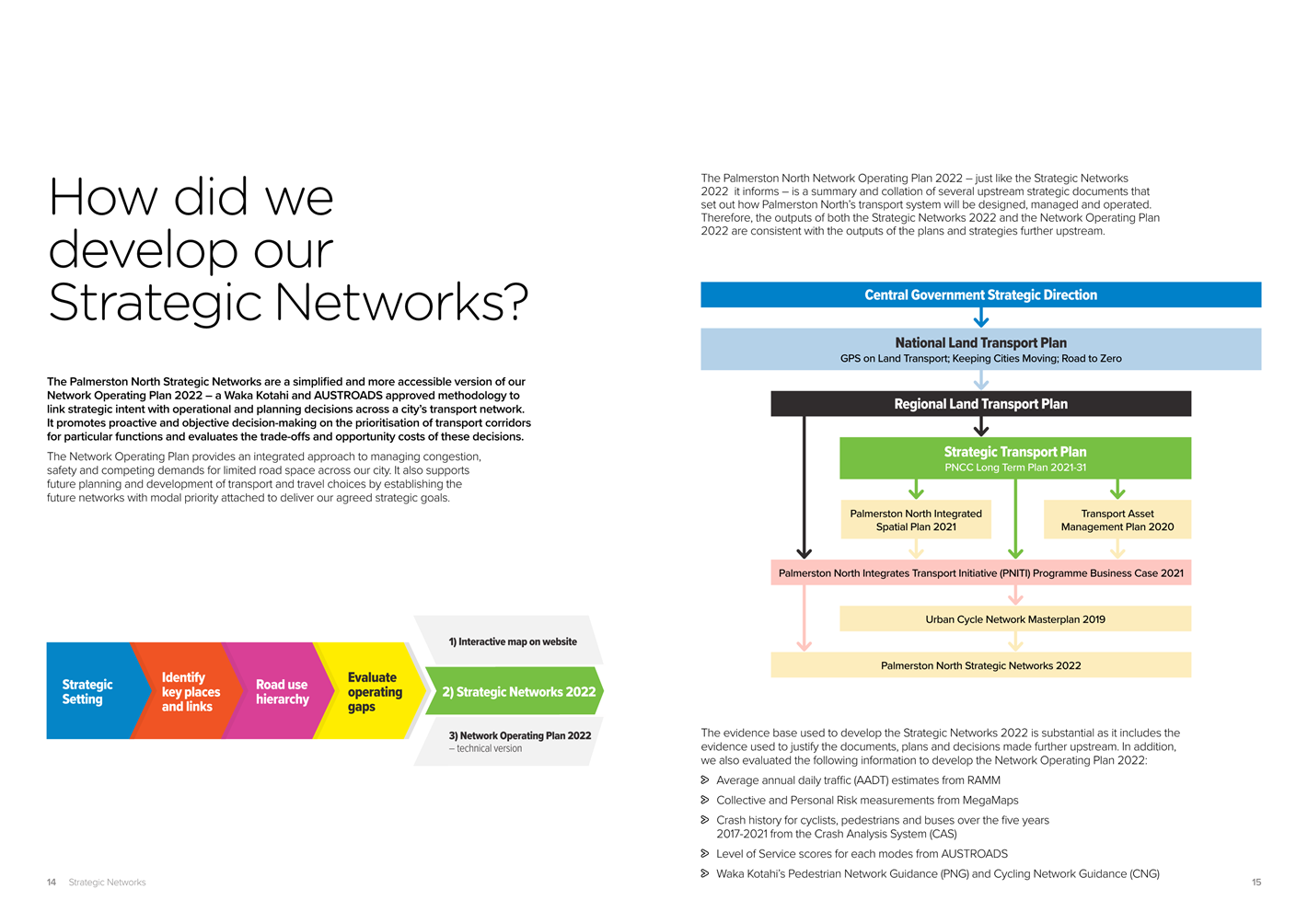
5. Methodology Undertaken
The development of the Palmerston
North Strategic Networks has followed Waka Kotahi’s nationally consistent
Network Operating Plan (NOP) process to draw links between strategic intent and
operational/planning decisions.
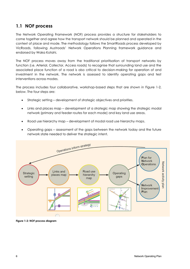
NOPs follow an integrated
process that helps councils across New Zealand better manage and plan the use
of their transport networks. It is currently difficult to provide a consensus
view on Palmerston North’s transport strategy over the long term, and to
articulate why a certain mode or use is prioritised over others, and how
certain decisions can have wider network impacts.
The NOP also allows for a more
holistic vision of transport systems that focuses on:
· Moving
people and goods, not vehicles
· Seeing
transport as supporting broader city & community goals
· Balancing
the competing demands for limited road space
· Considering
the ‘network’ rather than sites or routes

The methodology employed also
sought to consolidate the city’s existing transport planning and land-use
planning context rather than introduce/propose new interventions and projects.
Upon completion of the PNITI
Network Options Report – and subsequent Waka Kotahi board endorsement
– in early 2021, officers from PNCC, Waka Kotahi and Horizons undertook
the jointly funded Palmy Transport System Improvement Plan (PTSIP) which aimed
to consolidate Palmerston North’s existing transport plans to form an
integrated multi-modal view of place and movement priorities to best support
the city’s transport system. The PTSIP also looked to provide a
consistent plan to help PNCC and Waka Kotahi collaboratively develop and
deliver interventions necessary to support sustainable growth management,
improve multi-modal accessibility, and support the medium to long-term delivery
of the PNITI programme. The outputs of PTSIP are presented in Attachment 4.
The outputs of PTSIP were
directly fed into the NOP process as per the immediate recommended action in
PTSIP. This allowed for a quantitative and evidence-based ‘audit’
of Palmerston North’s existing transport plans to ensure alignment was
clear across all aspects of both council and the Waka Kotahi work
programme.
Many sources of information and
guidance were used to ensure the outputs of the NOP – and in turn
Palmerston North’s Strategic Networks – were fit-for-purpose and
aligned with the best possible national and international technical standards.
The final outputs are therefore
supported by substantial evidence used to justify the documents, plans and
strategies further upstream (i.e. PNITI Network Options Report, Urban Cycle
Network Masterplan etc.) and the additional sources below used to develop the
Strategic Networks:
• Average
annual daily traffic (AADT) estimates from RAMM
• Collective
and Personal Risk measurements from MegaMaps
• 2017-2021
crash history for cyclists, pedestrians and buses from the Waka Kotahi Crash
Analysis System (CAS)
• Level of
Service scores for each mode from AUSTROADS
• Waka
Kotahi’s Pedestrian Network Guidance (PNG)
• Waka
Kotahi’s Cycling Network Guidance (CNG)
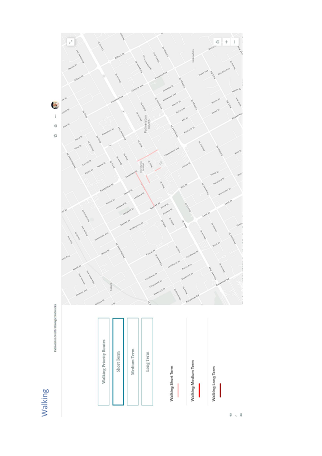
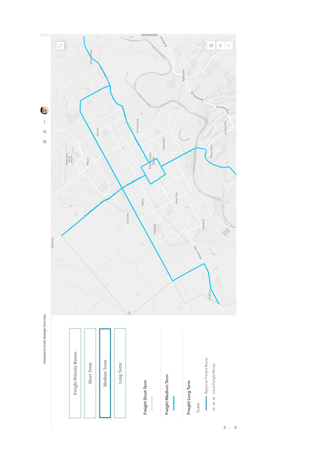
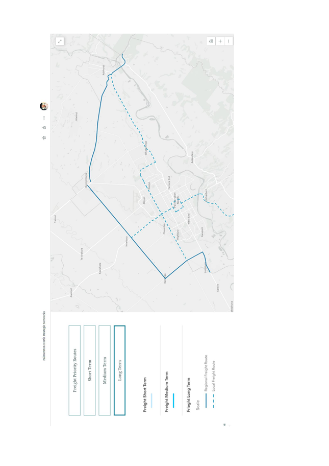
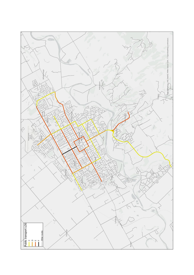
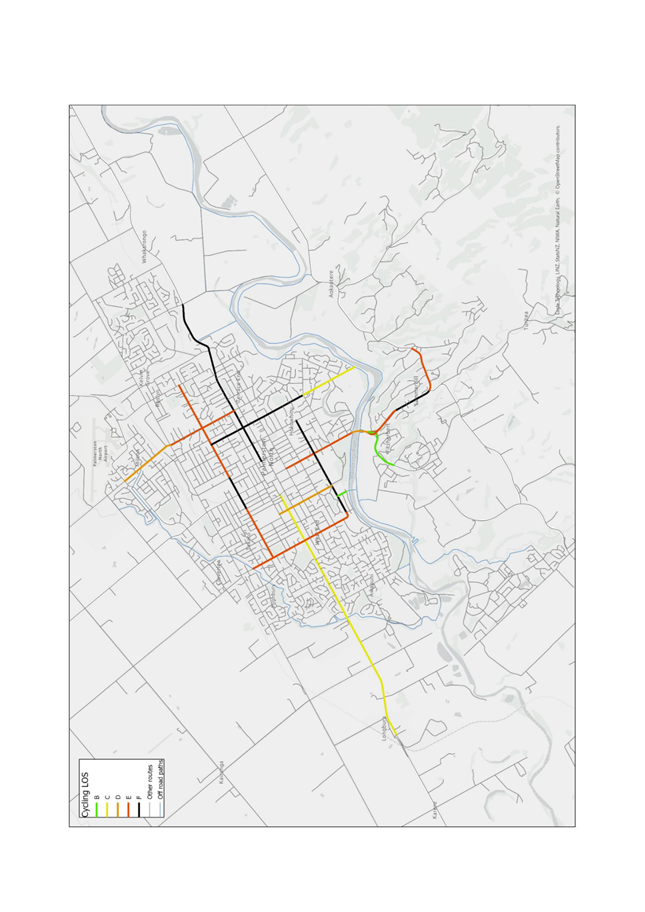
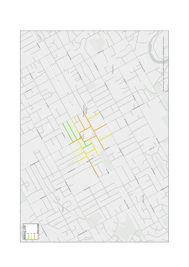
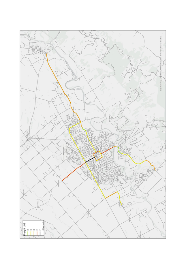
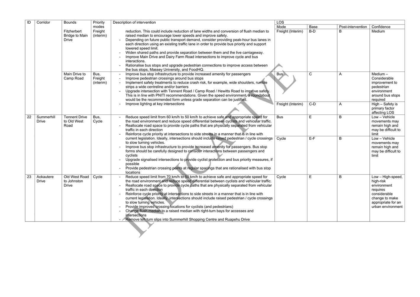
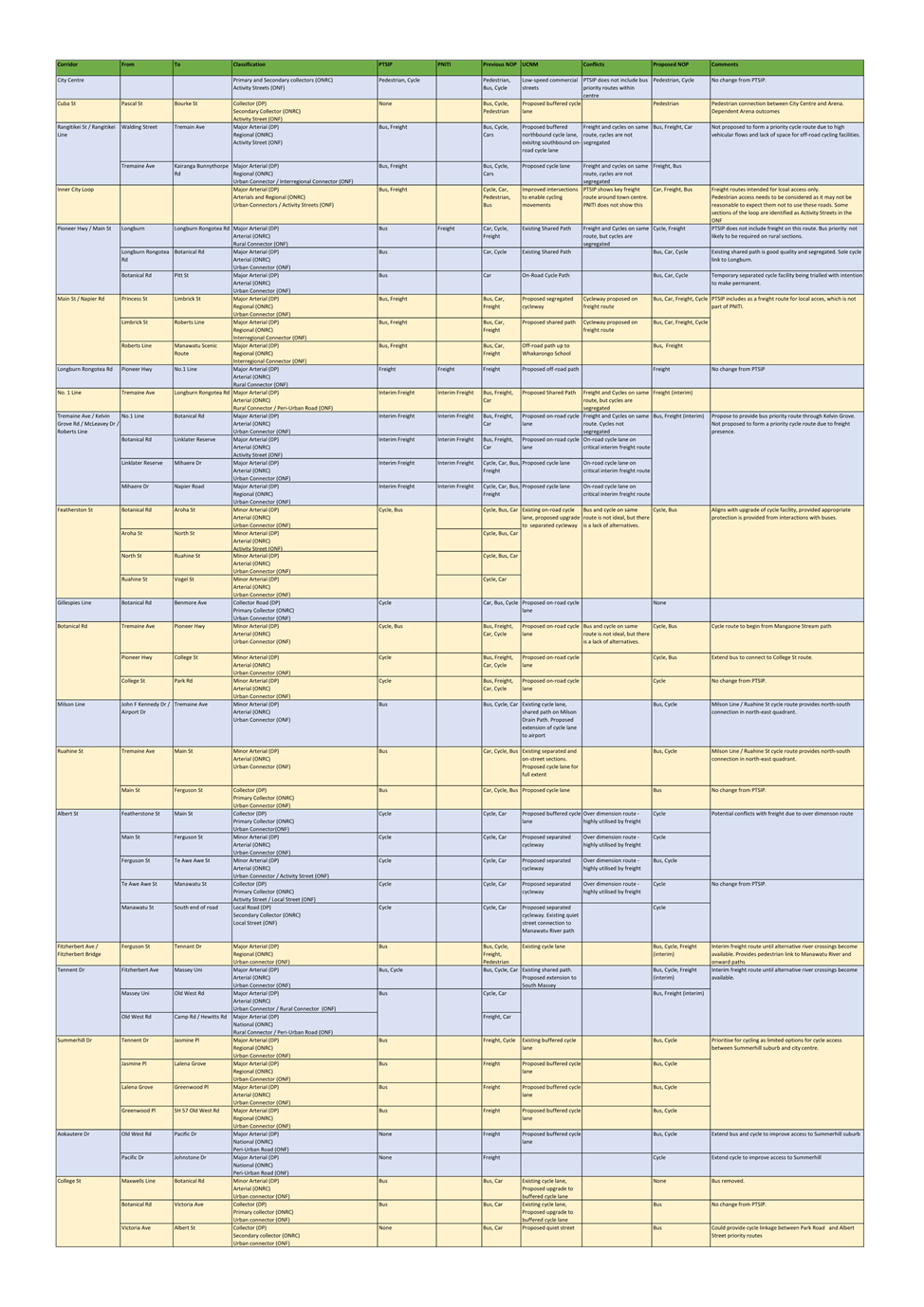
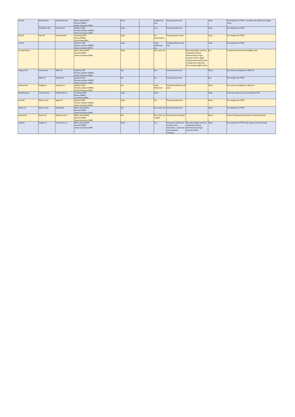
6. Palmerston north strategic networks
The Strategic Networks are presented in Attachment 2 for
five different modes, and outline how modal priorities will shift across
Palmerston North’s transport network over three time increments –
short, medium and long term. The increments align with those set out in the
PNITI programme, with further work (i.e. project specific planning) required to
provide a more accurate representation of when tangible changes are likely to
occur.
The Strategic Networks also consolidates the city’s
existing transport planning and land-use planning context rather than
introducing new interventions and projects. As they are effectively a
summarisation and clearer articulation of the strategic intent of existing
projects, there is no need to undertake public consultation on the networks.
Projects undertaken either by PNCC or partners Horizons Regional Council and
Waka Kotahi to give effect to the Strategic Networks will undergo their own
engagement and consultation processes.
The Strategic Networks also highlights where immediate
planning work is required to fill in existing gaps in the city’s
transport planning – for example, progressing the Indicative Business
Case for the Freight Ring Route to confirm the exact locations, alignment and
timing of the future Manawatu River Crossing, Bunnythorpe bypass and Ashhurst
Bypass.
The Strategic Networks will be viewable on the Council
website via an interactive Geographic Information System (GIS) webmap, where
our partners and members of the public will be able to easily view the
application of council’s strategic transport direction as it pertains to
specific roads and streets across the city.
A beta version of the webmap is viewable via this web
address: https://arcg.is/1XqnTS0.
Supporting the webmap will be a short summary document (Attachment 1) in
addition to the full technical report (Attachment 3) all available on the
website.
NOPs are intended as live documents that are consistently
updated as further planning, analysis and public engagement is undertaken,
hence the Strategic Networks will be refined and updated as council’s
land-use and transport planning work programmes are progressed. Furthermore,
new features may be added to the webmap in the interests of transparency and
more effective and meaningful communication, such as the programme of minor
works (i.e. pedestrian islands, raised pedestrian crossings etc.) in addition
to more significant works (i.e. cycle lanes, intersection upgrades, reseals
etc.).
7. NEXT STEPS
Upon the adoption of the
Strategic Networks, the following actions will be undertaken:
• Mayor/Chief
Executive/Chief Planning Officer to provide the foreword for the Strategic
Networks Summary Document
• The webmap,
Summary Document and Technical Report to be uploaded onto the Council Website
• Council
officers to work with Waka Kotahi to align work programmes and investment
proposals with the Strategic Networks, and maximise co-funding opportunities in
the short-term through the currently ongoing Regional Land Transport Plan
development
• Council to
progress with numerous transport planning projects to supplement the
information contained in the webmap
• Officers and
partners to continually update the Strategic Networks to ensure all information
is up-to-date, transparently presented and utilised to maximise future
co-funding opportunities
8. Compliance and administration
|
Does the Committee have
delegated authority to decide?
If Yes quote relevant clause(s)
from Delegations Manual
|
No
|
|
Are the decisions significant?
|
No
|
|
If they are significant do they
affect land or a body of water?
|
No
|
|
Can this decision only be made
through a 10 Year Plan?
|
No
|
|
Does this decision require
consultation through the Special Consultative procedure?
|
No
|
|
Is there funding in the current
Annual Plan for these actions?
|
Yes
|
|
Are the recommendations
inconsistent with any of Council’s policies or plans?
|
No
|
|
The recommendations contribute
to Goal 1: An Innovative and Growing City
|
|
The recommendations contribute
to the achievement of action/actions in Transport
Adoption of the Palmerston North Strategic Networks 2023
gives effect to all the actions within the Transport Plan, and is a key
element in future co-funding decision-making with Waka Kotahi/
|
|
Contribution to strategic
direction and to social, economic, environmental and cultural well-being
|
The Palmerston North
Strategic Networks 2023 have been developed in order to:
1. Enable
more travel choices by providing safe, easy to access and well-connected
networks for all modes.
2. Encourage
uptake of sustainable travel options to reduce transport emissions by making
public transport, walking and cycling appealing, safe, accessible and
enjoyable.
3. Develop
a transport system where no-one is killed or seriously injured in road
crashes by prioritising routes on corridors where high-quality infrastructure
is in place and reducing intermodal conflicts by separating priority routes
for the highest risk modes.
4. Match
modal priorities with place functions by prioritising general traffic and
freights movement where, while prioritising active modes and public transport
in place-based areas.
|
|
|
|
Attachments
|
1.
|
Strategic
Networks 2023 - Summary Document ⇩ 
|
|
|
2.
|
Strategic
Networks 2023 - Maps ⇩ 
|
|
|
3.
|
Strategic
Networks 2023 - Technical Report ⇩ 
|
|
|
4.
|
Palmy
System Transport Improvement Plan 2022 ⇩
|
|


Memorandum
TO: Economic
Growth Committee
MEETING DATE: 22
February 2023
TITLE: Process
and options to establish and enforce heavy vehicle routes
Presented
By: Vinuka
Nanayakkara, Senior Transport Planner; Peter Ridge, Senior Policy Analyst
APPROVED BY: David
Murphy, Chief Planning Officer
RECOMMENDATION TO Economic Growth Committee
1. That the
Committee receive the memorandum titled ‘Process and options to establish
and enforce heavy vehicle routes’ of 22 February 2023 to the Economic
Growth Committee.
1. ISSUE
On 24 November 2021, the
Finance & Audit Committee resolved that the “Process and options,
including the use of bylaws, to establish and enforce heavy vehicle routes in
the city’s transport network” be presented to the Planning &
Strategy Committee.
2. BACKGROUND
Palmerston North is home to a
regionally and nationally significant hub for freight, logistics and
distribution activities with aims to build on the existing activities to remain
competitive as the primary freight distribution hub in the lower North Island.
This provides a significant economic opportunity for the city, while also
placing pressures on existing infrastructure. Increases in the number of heavy
vehicle movements associated with this growth are creating safety and efficiency
issues on the transport network as well as impacting road quality. The
strategic response to these issues has been slow and uncertainty remains over
when improvements will be delivered and when growth will occur.
As Palmerston North has grown,
residential areas have developed in and around industrial areas resulting in
access, safety, and amenity issues, particularly due to freight movements. A
key reason for this is the lack of an explicit and coherently implemented road
hierarchy – i.e. obvious differences between high order and low order.
While traffic volumes are still relatively moderate, growing demand is expected
to further exacerbate these issues.
The quality of Palmerston
North’s road surfaces has been steadily decreasing over the past five-years,
with particularly high deterioration rates observed on the city’s busiest
roads. Several factors have contributed to this, including increases in the
volume and weights of heavy vehicles on Palmerston North’s roads, poor
underlying ground conditions, service and utility trenches and a lack of
investment for many years, particularly in inter-regional routes for heavy
traffic.
Mixed residential and
industrial areas, road network deficiencies on sections of the identified
freight route and a lack of suitable (i.e. optimised) routes for freight
movements results in heavy vehicles often re-routing through residential areas.
This results in higher than expected freight volumes on streets that were never
intended to cater for such demands. Modelling undertaken to inform the PNITI
Network Options Report showed relatively high volumes of truck movements
through predominantly residential streets, including past schools and community
facilities.
Heavy freight movements tend to
be governed by functions of time taken and distance travelled, and
Council’s 2018 freight demand study suggested that heavy vehicles are
permeating across the city’s network to find the easiest and most
convenient route to reach their destinations, regardless of the suitability of
the roads chosen.
|
|
 |
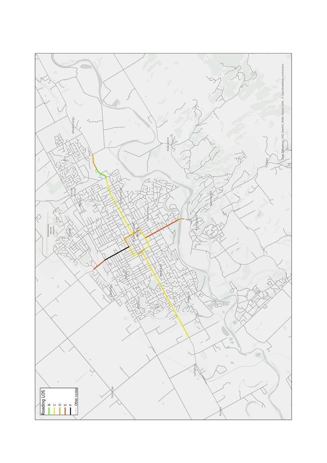
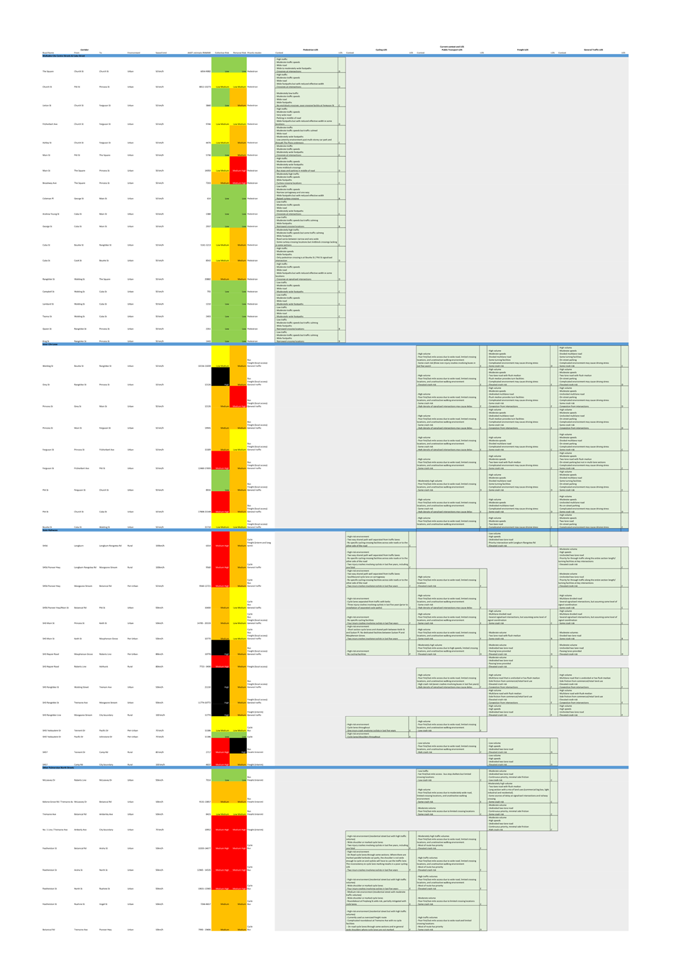
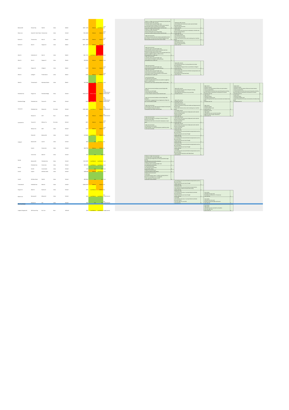
Figure 1 presents the weekday Heavy Commercial Vehicle (HCV) demand across
Palmerston North’s transport network in March 2018, sourced from EROAD
fleet data. The highest volumes of heavy freight traffic are generally observed
on Tremaine Avenue / Number One Line, across Kelvin Grove, the North East
Industrial Zone and along the numerous State Highway (SH3, 54, 56 & 57)
corridors across the city. In addition, increased heavy vehicle traffic was also
observed along streets with higher emphasis on residential land-use such as
Park Road, Maxwells Line, Te Awe Awe Street, Albert Street, Ruahine Street and
Botanical Road, suggesting the freight hierarchy is not well defined.
Opportunities therefore exist to further encourage freight traffic to use
particular routes that are currently more suitable, implement changes to the
network to make certain routes more attractive, or to disincentivise freight
traffic from using certain routes across the network.
3. Options to establish heavy vehicle routes
The
identification and establishment of “heavy vehicle routes” or any
other priority routes based on mode can’t be done without considering a
number of parameters such as current and future land-use, strategic city-wide
goals, speed limits, roading hierarchy, engineering feasibility and condition
of road assets among others.
As
freight movements will utilise the quickest, most direct and most reliable
routes regardless of the types of activities occurring on or along any
particular road, it’s likely that heavy vehicle traffic will not utilise
any specified priority freight routes unless there are significant time,
distance and/or efficiency benefits for operators. Therefore, maintaining a
route that is appealing for heavy vehicle traffic is largely attributed to the
infrastructure along a route.
While
the roading infrastructure along priority freight routes may support heavy
vehicle traffic, other factors need to also be considered and evaluated. For
example, land-use (i.e. residential properties or school entrances fronting
onto a road), asset condition (i.e. understrength pavements) and other
transport priority routes (i.e. buffered cycleways or bus priority routes) may
mean certain corridors are unsuitable as a freight priority route.
Standard
transport planning practice will seek to determine whether adverse impacts will
be generated by placing unreasonable demands for what street may be able to
safely and realistically accommodate, and then seek to mitigate these impacts
across the network.
Council
has requested advice on the available tools that can be used to manage the
impacts of heavy traffic. As it stands, there are two distinct approaches
available to identify and establish heavy vehicle routes:
Option 1: Palmerston North
Integrated Transport Initiative (PNITI)
PNITI is Palmerston North’s
overarching and integrated land-use/transport plan containing a series of
actions across the short, medium and long term to manage the impacts of heavy
vehicle traffic across the city’s urban network. It balances Palmerston
North’s aspirations of being a strategic cog in the national freight
supply chain with the need to ensure that amenity, road safety, transport
emissions and liveability aspects are also improved across the city.
PNITI aims to achieve several
benefits across the short, medium and long term, including:
· Reduction
of heavy vehicle movements on residential (place-based) streets by up to 50%;
· Reduction
in the number of congested intersections by 50%;
· Improvements
in journey times on key freight routes by up to 10 minutes; and
· Supporting
economic development around the North East Industrial Zone (incl. KiwiRail
Freight Hub).
The
first step in PNITI is the development of strategic priority routes for the
different modes of transport across Palmerston North – referred to as the
System Improvement Plan, delivered within Waka Kotahi’s Network Operating
Planning (NOP) process. The NOP is a nationally recognised process for
prioritising different modes along streets, which in turn informs where
interventions/investment should be focused. It also identifies where potential
trade-offs may be required to achieve the intended strategic transport
outcomes.
Palmerston
North’s newest NOP – referred to as the Strategic Networks
– identifies the core functions of key routes and significant places
across the city by accounting for the outputs of several existing transport
plans and strategies (i.e. District Plan, Urban Cycle Network Masterplan, City
Centre Framework etc.). This then allows for an objective and evidence-based
process to establish the most appropriate routes for heavy vehicles while also
effectively balancing access, place, and transport amenity.
The
use of a Waka Kotahi planning process is highly beneficial to the city as
direct links can be drawn between Waka Kotahi’s funding processes and
Council’s strategic transport plans.
The
development of Palmerston North’s Strategic Networks (NOP) commenced in
early 2021 and featured close collaboration with officers from Waka Kotahi and
Horizons Regional Council (HRC). The Strategic Networks will be brought to
committee in 2023, alongside this report.

Option 2: Provisions within the Traffic
& Parking Bylaw 2018
The
Traffic and Parking Bylaw sets out the controls and restrictions that the
Council can impose on how roads are used and is made pursuant to Section 22AB
of the Land Transport Act 1998. The Bylaw sets out Council’s right to define
and restrict the use of local roads (i.e. those that are not private or State
Highways) and defines the methods of signifying controls on the use, stopping,
standing and parking of vehicles on roads and Council controlled places in
Palmerston North.
With respect to the use of local
roads, the Bylaw enables Council to:
- “Prohibit
or restrict, absolutely or conditionally, any specified class of traffic or any
specified motor vehicles or class of motor vehicle that, by reason of its size
or nature or the nature of the goods carried, is unsuitable for use on any road
or roads.”
- Restrict the
driving of livestock “along or across any road in the urban area of
the district” unless “the person driving the stock holds a
permit issued by the Council, and complies with the conditions of that
permit.”
- Restrict the
transportation of stock in heavy motor vehicles across all roads within the
“Inner Ring Road” – bounded by Princess Street, Ferguson
Street, Pitt/Bourke Street and Walding/Grey Street – at all times.
With
respect to parking restrictions on local roads, the Bylaw currently enables
Council to:
- “Limit
the stopping, standing or parking of vehicles on any road to vehicles of any
specified class or description of vehicle”
- “Prohibit
or restrict the parking of heavy motor vehicles, or any specific class or
description of heavy motor vehicle, on any specified road during specified
hours for a period that exceeds a specified period.”
Changes
to the existing Bylaw can be made at any time by Council provided appropriate
consultation occurs in accordance with the decision-making requirements of
Section 82 of the Local Government Act 2002 and with sufficient justification
and supporting evidence – albeit possibly less than a transport planning
approach if appropriate planning work has not been undertaken.
If
an absence of strategic transport plans existed alongside a desire to implement
interventions prior to completing the necessary technical analysis, the
relatively quick (6-12 month) process of pursuing a regulatory approach to
solve the issue would have merit.
Bylaws
are not the principal instrument for setting strategic direction or
establishing policy. Instead, they are best reserved for implementing
regulatory approaches that support strategic or policy direction. A bylaw that
imposes restrictions without the necessary supporting strategic considerations
is more likely to be ad hoc and lead to unintended consequences and poor
outcomes, such as are inconsistent with wider strategic transport planning,
land-use planning and/or the rest of Council’s transport infrastructure
delivery programme
Furthermore,
any prohibitions/restrictions on specific routes because of the size of the
class of traffic raises the risk of legal challenges on the grounds that it may
be unreasonable. A bylaw which is based on a sound strategic evaluation of the
transport network and was able to show evidence of the unsuitability of that
route for that class of traffic, then it is more likely to withstand a legal
challenge. However, it could still be argued that an individual vehicle
alone is suitable, even if the class of traffic is creating an unreasonable
burden on the route. A regulatory approach alone, therefore, may not be the
most effective way of redirecting heavy vehicles to use priority routes.
Analysis of Options 1 & 2
|
|
Option 1: PNITI
|
Option 2: Bylaw
|
|
Pros
|
- Any
priority routes are considered within the city’s existing strategic
context, therefore more likely to achieve the intended outcomes
- Identified
priority routes can be included in the existing work programme focused on
resolving negative impacts of heavy vehicle traffic, hence no added
requirement for staff/resources
- Maintains
alignment with other ongoing transport interventions & land-use
planning/projects
- Opportunities
exist to receive Waka Kotahi co-funding for planning & operational work
|
- Provides
a very clear and concise way of identifying the routes on which heavy
vehicles are restricted.
|
|
Cons
|
- No official/legal status
designated to specific roads
|
- Potential legal issues with
imposing restrictions on routes that are technically able to accommodate
heavy vehicles
- Independent of the existing
strategic transport context, therefore more likely to have wider strategic
implications if interventions aren’t appropriately evaluated, tested
and consulted on
- Bylaw amendment process is
additional to existing workload and will require specific funding or existing
work to be reprioritised
|
4. Implementation & operation of heavy
vehicle routes
Regardless of how priority routes
for heavy vehicles are identified, achieving compliance with the routes is
critical to ensuring the intended outcomes are met. Ensuring a high degree of
compliance with heavy vehicle routes can be done through two approaches:
Option 1: Infrastructure
Detuning/Optimisation
Disincentivising certain routes while optimising others for heavy vehicles is
the most effective way to achieve desired changes to the routes chosen by heavy
vehicle traffic. The former can be achieved in a number of ways such as the
narrowing of roads, installation of speed bumps / raised tables (Figure 2),
tighter turns (Figure 3) and the signalisation of currently uncontrolled
intersections (Figure 4).

Infrastructure interventions generally provide valuable new
opportunities to improve the quality of urban realm for pedestrians and people
on bikes since road space can be reallocated in favour of active modes,
existing safety risks can be reduced, and road space is repurposed for
treatments such as increased vegetation.
While infrastructure interventions
have a relatively high capital cost for implementation, they benefit from not
requiring significant operational expenditure for additional ongoing compliance
monitoring and active enforcement.
However, the degree to which
treatments can provide the intended outcomes is highly contextual and requires
specific technical analysis for each location. Any infrastructure changes
implemented to re-route heavy vehicle traffic will need to cause significant
increases to either the distance travelled, or additional time incurred by
heavy vehicle movements for the interventions to have any tangible return on
investment. This can be highly unpopular since any impacts on heavy vehicle
movements are likely to also affect general traffic.
The effectiveness of any
interventions will also depend on whether more suitable and/or preferable
routes for heavy vehicles exist. The optimisation of traffic signals and
installation of slip lanes and (rural) roundabouts among other interventions
along preferred freight priority routes alongside any detuning efforts is key
to ensuring that the outcomes Council are trying to achieve are realised.
It’s also critical that all interventions be aligned to existing
strategic (national, regional and local) transport plans so the likelihood of
changes to Palmerston North’s transport network contradicting each other
is fully mitigated.
Improving the efficiency of traffic
flow along routes more appropriate for heavy vehicles – i.e. Tremaine
Avenue, Fitzherbert Avenue, Pioneer Highway and State Highway 3 – may
achieve similar outcomes to attempting to slow freight traffic on more
“place-based” streets. The optimisation of through movements at
existing signalised intersections and reduction of “side-friction”
(e.g. on-street carparking) among other interventions all contribute to the
reduction or reliability of travel time and/or distance, making certain routes
far more attractive for operators to use.
Improving the efficiency of
certain routes is likely to have a significantly more positive public and
operator response in addition to the relatively low ongoing operational
monitoring and enforcement resourcing requirements. Any such interventions
should still be aligned to all local and regional strategies to ensure that the
intended outcomes are achieved while minimising any unintended impacts to
residents along certain routes.
Option 2: Regulatory Approaches
All regulatory approaches that are
employed by Council to implement heavy vehicle priority routes will be governed
by the Traffic and Parking Bylaw – in turn governed by Section 22AB of
the Land Transport Act 1998 – and will require ongoing active monitoring
and enforcement to ensure a high degree of compliance.
Under Section 128E of the Land
Transport Act 1998, Parking Officers have the authority to enforce stationary
vehicle offences only (i.e. parking violations and expired WOF / Registration
offences). While the Police can legally enforce both stationary and moving
vehicle offences (i.e. speed limits & state highway weigh-stations), they
tend to leave the former to councils unless an event poses a significant safety
hazard to the public.
Therefore, the responsibility of
enforcing any future bylaw amendment would lie with the Police. Effective
enforcement would also require a new monitoring programme to identify offending
vehicles (either officers physically observing compliance or installation of traffic
cameras) and collect evidence of breaches of the bylaw for prosecution.
However, the cost of prosecution combined with typically small fines set by the
Court following conviction would likely make this a cost-inefficient approach
for Council.
No resources – both staff
and equipment – or budgets currently exist to undertake the active
enforcement of heavy vehicle routes across Council staff, and the capacity for
the Police to enforce any future heavy vehicle restrictions has not been evaluated
for this memo.
Additionally, using Clause 10 to
prohibit or restrict certain routes for specified types of vehicle could be
impractical and expensive to enforce. Signage along the route would be required
to communicate the prohibition or restriction, and if the intent is to divert
heavy vehicles to a preferred route, then it would likely require signage
across all the other roads across the city deemed not suitable for heavy
vehicles.
The installation of signage
requires technical analysis to identify safe and appropriate locations for
signs, as well as extensive engagement and consultation with operators and the
general public, in addition to targeted engagement with adjacent property
owners where existing infrastructure may not currently exist. While the unit cost
of signage will be relatively low, the number of signs that may be required
along certain routes in addition to supporting infrastructure (i.e. poles,
lights, footings) and the purchase of land if required likely means the use of
signage may be a cost-intensive process. Budget and resources do not currently
exist for the installation of signs restricting heavy vehicle traffic, hence
both will need to be sought from the reallocation of other existing activities.
Analysis of Options 1 & 2
|
|
Option 1:
Infrastructure
Detuning/Optimisation
|
Option 2: Regulatory
Approaches
|
|
Pros
|
- Many
infrastructure interventions likely require little to no active and/or
ongoing enforcement
- Considered
within the city’s existing strategic context, therefore more likely to
achieve the intended outcomes
- Included
in existing work programme focused on resolving negative impacts of heavy
vehicle traffic, hence no added requirement for staff/resources
- Maintain
alignment with other ongoing transport interventions & land-use
planning/projects
- Co-funding
opportunities exist from Waka Kotahi for capital new and maintenance work
- Interventions
are likely to have the intended effects over the life of the assets (i.e
long-term)
|
|
|
Cons
|
- Some interventions will be
dependent on the delivery of preceding projects, hence achieving the intended
outcomes may be dependent on Council’s commitment to the wider
programme
- Interventions are likely to
have high capital costs and require further technical analysis & design
work before implementation
|
- Council has no ability to
enforce moving vehicle offenses
- Enforcement sits with the
Police whose capacity and willingness to take on the responsibility is
unknown
- Likelihood of compliance is
low, as low fines are unlikely to act as deterrent to operators
- High ongoing costs &
officer time attributed to ongoing monitoring and prosecution
|
5. Additional option for consideration
Engagement with Freight Operators
A cost-effective approach which
will likely achieve similar or better outcomes than the regulatory or
infrastructure approaches outlined would be to proactively engage and
collaborate with the largest freight operators and other identified heavy
vehicle operators across Palmerston North to develop preferred routes for heavy
freight. While involvement from industry would be voluntary, operators may
either consider voluntarily changing their routes if the Council can present
valid reasons for the removal of heavy vehicle traffic along certain routes.
Collaborating with operators also provides a valuable opportunity to test and
evaluate potential future interventions before implementation and maximise the
possibility of success.
This approach is already being
undertaken for the development of the Te Utanganui – Central New Zealand
Distribution Hub Masterplan and will form a key role for the continuation of
the PNITI programme.
6. Compliance and administration
|
Does the Committee have
delegated authority to decide?
If Yes quote relevant clause(s)
from Delegations Manual
|
Yes
|
|
Are the decisions significant?
|
No
|
|
If they are significant do they
affect land or a body of water?
|
No
|
|
Can this decision only be made
through a 10 Year Plan?
|
No
|
|
Does this decision require
consultation through the Special Consultative procedure?
|
No
|
|
Is there funding in the current
Annual Plan for these actions?
|
No
|
|
Are the recommendations
inconsistent with any of Council’s policies or plans?
|
No
|
|
The recommendations contribute
to Goal 1: An Innovative and Growing City
|
|
The recommendations contribute
to the achievement of action/actions in Transport
|
|
Contribution to strategic
direction and to social, economic, environmental and cultural well-being
|
Options developed in this report
will assist in achieving the action prioritise transport programmes that
deliver on Council goals, the purpose of the Transport Plan, and the
Government Policy Statement on Transport.
|
|
|
|
Attachments
Nil
TO: Economic
Growth Committee
MEETING DATE: 22
February 2023
TITLE: Main
Street Cycleway - Permanent Solution Decision
PRESENTED BY: Hamish
Featonby - Group Manager Transport and Development
APPROVED BY: Sarah
Sinclair, Chief Infrastructure Officer
RECOMMENDATION TO Council
1. That Council
endorse Option 1: Retain the existing Pioneer Highway shared pathway
infrastructure until it reaches the end of its useful life and replace it and
progress the remaining pieces as a permanent solution to create a complete and
safe cycleway along that route.
Rationale for the recommendations
1. Overview of the problem or opportunity
1.1 The
cycleway infrastructure that replaced the planter boxes on Main Street West was
intended as semi-permanent until a permanent solution could be designed. An
opportunity exists to keep that infrastructure in place until it reaches the
end of its’ useful life, rather than replace it now, as it is proving
effective in place.
1.2 This
would reduce the scope of the planned permanent and route completion work to
include only the construction of the missing pieces between that cycleway and
the shared path on Pioneer Highway.
2. Background and previous council decisions
2019 Urban Cycle Network Masterplan, 2021-31 10 Year and
Transport Plans
2.1 Council
adopted an Urban Cycle Network Masterplan in 2019. Its purpose is to map out an
investment programme for the urban cycle network and to create an environment
and culture that encourages more people in Palmerston North to choose cycling
more often. The Urban Cycle Network Masterplan commits Council to (but not limited
to):
· Expand
the network of cycle lanes, including physically separated cycleways
2.2 The
implementation of the Urban Cycle Network Masterplan was endorsed in the most
recent 10 Year and Transport Plans. The Transport Plan signals that one of the key
measures of success for the plan is an increase in walking and cycling. The
Transport Plan also highlights that in Palmerston North only a small proportion
of total trips incorporate active transport, that fatal and serious injury
crashes involving cyclists continues to increase and that the perception of
cycling as unsafe is a key barrier to an increase in cycling uptake.
2.3 The
Innovating Streets for People was a Waka Kotahi NZ Transport Agency initiative
during 2019-21 period that aimed to make it easier for councils to create
safer, healthier and more people-friendly towns and cities. The Innovating
streets pilot fund supported quick, low-cost interim improvements focused on
delivering streets that put people first. The projects involved users, businesses,
residents, iwi and stakeholder groups to ensure the design was appropriate. One
of the outcomes of the programme was to build capability in this approach
across the country so more councils could start to take this approach to street
changes, making the necessary alterations in a faster and more responsive way.
Innovating Streets – Main Street West
“Planter Boxes”
2.4 Following
public consultation, the Urban Cycle Network Masterplan 2019 confirmed Main
Street West/Pioneer Highway as a priority route for the development of a
separated cycleway.
2.5 In
April 2021, Council successfully gained 90% co-funding from Waka Kotahi (NZTA)
Innovating Streets programme to trial a cycleway along Main Street West,
between the intersection of Pitt Street and Botanical Road, using coloured
planter boxes and other materials as separators.
2.6 Although
extensive engagement was conducted with the community prior to installation,
previous Council reports have reported on the mixed success of the planter boxes.
2.7 Many
cyclists were satisfied with the increased safety they enjoyed along the
physically separated cycleway, while other road users and members of the public
voiced their concerns about a range of issues, both through social media and
the contact centre. The boxes were subjected to some vandalism, and created
some operational issues to manage them, many of which were resolved.
2.8 A
road safety audit conducted by BECA in June 2021 recommended improvements to
some moderate and minor issues. This focussed predominantly on risk to life,
and found that while the cycleway generally worked well, several issues
required resolving. These issues related to intersection conflicts,
planter box stability and visibility, narrow cycle lane and on street parking/loading
conflicts, drainage maintenance and refuge collection access. The visibility
issue in particular resulted in several vehicle to box conflicts.
2.9 Cycle
count monitoring showed that user numbers almost tripled within the first month
of operation (from 6/hr in November 2020 to 17/hr in May 2021), a notable
result given the seasonal differences. Follow up user surveys found that 90% of
intercepted cyclists rated it highly positively (overwise neutral), compared
with 0% previously (overwise neutral or negative).
2.10 Officers
recommended to Council that whilst the trial of the cycle lane was a success,
plastic planter boxes were not a viable solution alongside live traffic and
would not be used again in a roadway environment in Palmerston North.
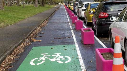
Figure 1: Planter Boxes on Main St West
Temporary Solution
2.11 At the
Council meeting on 6 April 2022 Council resolved “That Council removes
the ‘planter boxes’ as soon as practicable and replaces immediately
with an alternative solution before the permanent cycleway is in place.”
2.12 Fulton
Hogan were instructed and subsequently installed just under $60k worth of
Vanguard separators and posts in place of the Planter Boxes and stored the
Planter boxes at the Depot. The majority of the Planter Boxes were subsequently
donated to the public through an expression of interest process.
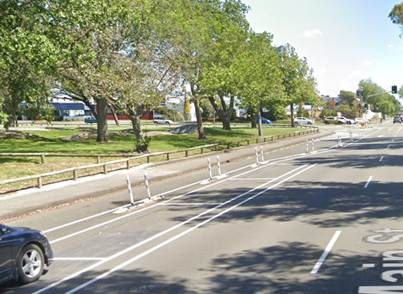
Figure 2: Temporary Vanguard separators and posts
3. options
3.1 The
tables below describe the options being considered for Main Street West from
Pitt Street through to Pioneer Highway. The pictures below the tables provide
context to the options discussed.
|
OPTION 1:
|
(a) Keep
the infrastructure already there until it reaches the end of its useful life
and then replace it
(b) Construct
the remaining pieces as a permanent solution to create a complete and safe
cycleway along that route
|
|
Community Views
|
Not recently tested.
Parts of the community will be expecting a decision consistent with the
previous resolution of council to construct a permanent solution.
|
|
Benefits
|
The community will
receive a complete and cohesive cycleway with investment only required to
fill the gaps. Deferral of replacement costs of existing infrastructure for
approximately 5 years.
|
|
Risks
|
Existing infrastructure
not lasting as long as expected so requiring replacement or upgrade sooner.
Not seen to be
delivering on the previously signalled permanent solution.
|
|
Financial
|
Existing Infrastructure
|
Completing the Route
|
Operational on existing
cycleway
|
|
$0
|
$750k
|
$5k per year
|
|
Permanence of Decision
|
Can change decision in
the future to permanent solution. Cannot easily change decision to complete
the route.
|
|
OPTION 2:
|
(a) Keep
the infrastructure already there until it reaches the end of its useful life
and then replace it
(b) Do
not construct the missing pieces of that route.
|
|
Community Views
|
Not recently tested.
Parts of the community will be expecting a decision consistent with the
previous resolution of council to construct a permanent solution.
|
|
Benefits
|
No capital investment
required until end of useful life of the infrastructure in approximately 5
years.
|
|
Risks
|
An incomplete cycle
route leaves a safety risk and a potential for a lower uptake of cycling.
Not seen to be
delivering on the previously signalled permanent solution.
|
|
Financial
|
Existing Infrastructure
|
Completing the Route
|
Operational on existing
cycleway
|
|
$0
|
$0
|
$5k per year
|
|
Permanence of Decision
|
Can change decision in
the future to a permanent solution and to complete the route.
|
|
OPTION 3:
|
Replace the infrastructure already
built with a more permanent solutionConstruct the missing pieces as a
permanent solution to create a complete and safe cycleway along that route.
|
|
Community Views
|
Not recently tested however
this is the option the public are expecting currently given the earlier
resolution passed by Council. There is potential for a negative reaction to
replacing infrastructure at that location again so soon.
|
|
Benefits
|
A more permanent solution now
would mean a longer timeframe before renewal is required and less operational
maintenance over the short to medium term. The community will receive a
complete cohesive cycleway along that route.
|
|
Risks
|
Reputational risk from removing
functioning infrastructure to replace it with a similar but longer lasting
solution.
|
|
Financial
|
$470k to replace the existing
infrastructure with a more permanent solution and $750k spent on the gaps.
|
|
Financial
|
Existing Infrastructure
|
Completing the Route
|
Operational on existing
cycleway
|
|
$470k
|
$750k
|
$0
|
|
Permanence of Decision
|
Cannot easily change decision
to replace with permanent infrastructure and complete the route.
|
3.2 Plan
view of the existing temporary infrastructure in blue, a new signalised
crossing in red and the missing pieces to connect the route to the rest of the
network in green.
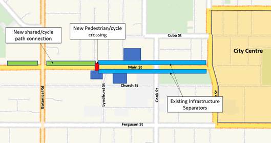
3.3 Location
of the new signalised crossing. This location would create no material impact
on the entrance to the shopping centre and would provide a safe crossing for
cyclists and pedestrians to either continue away from the city centre along a
shared pathway but also to access Burns Avenue. It would replace the pedestrian
refuge currently in place.
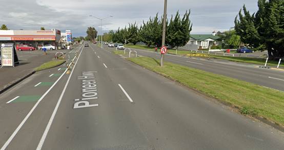
3.4 Example
location of the new sections of shared path that will complete the route. Note
that current design will avoid removal of any trees but may require some minor
pruning in some instances.
3.5 Possible
permanent solution example. In a similar manner to the intersection of Main and
West Street, a permanent solution would likely include concrete separators
because of the risk.
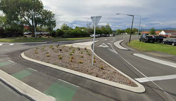
4. Financial
4.1 Operational
The temporary separators require some ongoing maintenance,
specifically to replace the posts as they are damaged occasionally. Based on
the costs since installation, officers predict a $5k investment required per
year from the Traffic Services Maintenance budget. This requirement will be
included in the LTP discussions for future budgets but for the 2022/23
financial year it can be accommodated.
4.2 Capital
Renewal / New
When the temporary separators have reached the end of their
useful life in approximately 5 years a decision will be required on whether to
replace with similar or to improve to a more permanent solution such as
concrete. Based on todays’ prices a like for like replacement would cost
$60k plus installation of approximately $40k and a permanent one closer to
approximately $470k including installation. At this time there is no budget for
this work in the 2022/23 budget or signalled for the 2023/24 budget. Depending
on the decision to move to concrete or not the budget could be Renewal or
Capital New.
To complete the shared pathway section requires
approximately $350k which can be accommodated within the existing 2022/23
Capital New budget 2121 City-wide – Footpath Improvements if the
recommended option is implemented. It should be completed during this
construction season by Fulton Hogan.
The signalised crossing requires further design and
expected delivery timeline is during the 2023/24 financial year. The expected
cost is approximately $300k from the Capital New budget 2121 City-wide –
Footpath Improvements which can be accommodated within currently proposed
funding.
5. conclusion and recommendation
5.1 The
temporary cycle barrier now installed along Main street is proving effective
and has a remaining life of five years. It is therefore recommended that this
is kept in place, as a cost-effective solution, until the end of its useful
life.
5.2 To
create a link into the city, some further elements of the cycle lane are needed
to connect with the existing off-road cycle lane on Pioneer Highway. It is
recommended that this is done, to maximise the effectiveness of the cycle lane
provision and hence maximise the effectiveness of the investment made to date.
5.3 Option
1 is therefore recommended to Council.
6. Next actions
6.1 If
the recommended Option One is endorsed, implementation will be confirmed with
Fulton Hogan. Designs are almost complete for the extension of the shared
pathway and will be delivered by Fulton Hogan during the 22/23 financial year
and design for the crossing will be started in time for a 23/24 delivery.
6.2 The
Annual Plan and Long Term Plan (LTP) will be updated to include the maintenance
cost for the Vanguard solution.
6.3 The
LTP proposal next year will include a provision for the development of a new
barrier once the Vanguard reaches the end of its useful life.
7. Outline of community engagement process
7.1 If
the option to implement a signalised crossing is endorsed, then engagement and
consultation will occur with affected parties such as the shop owners and
residents within the vicinity in order to allow them an input into the outcome.
7.2 Notification
will occur prior to any physical works occurring.
Compliance and administration
|
Does the Committee have
delegated authority to decide?
If Yes quote relevant clause(s)
from Delegations Manual
|
No
|
|
Are the decisions significant?
|
No
|
|
If they are significant do they
affect land or a body of water?
|
No
|
|
Can this decision only be made
through a 10 Year Plan?
|
No
|
|
Does this decision require consultation
through the Special Consultative procedure?
|
No
|
|
Is there funding in the current
Annual Plan for these actions?
|
Yes
|
|
Are the recommendations
inconsistent with any of Council’s policies or plans?
|
No
|
|
The recommendations contribute
to Goal 1: An Innovative and Growing City
|
|
The recommendations contribute
to the achievement of action/actions in Transport
The action is: Increase walking
and cycling
|
|
Contribution to strategic
direction and to social, economic, environmental and cultural well-being
|
The Transport Plan signals that
one of the key measures of success for the plan is an increase in walking and
cycling. The Transport Plan also highlights that in Palmerston North only a
small proportion of total trips incorporate active transport, that fatal and
serious injury crashes involving cyclists continues to increase and that the
perception of cycling as unsafe is a key barrier to an increase in cycling
uptake. This project works towards creating a safe and inclusive cycling core
network.
|
|
|
|
Attachments
Nil
Work schedule
TO: Economic
Growth Committee
MEETING DATE: 22
February 2023
TITLE: Work
Schedule - February 2023
RECOMMENDATION TO Economic Growth Committee
1. That the
Economic Growth Committee receive its work schedule for February 2023.
Committee
Work Schedule 2023
|
|
Estimated Report
Date
|
Subject
|
Officer Responsible
|
Date of Instruction
&
Clause no.
|
|
1
|
22 Feb 2023
|
Process and options, including the use of bylaws, to
establish and enforce heavy vehicle routes in the city’s urban
transport network
|
Chief Planning Officer
|
Finance & Audit
Committee
24 Nov 2021
Clause 82-21
|
|
2
|
12 April 2023
|
Update on infill
lighting required to achieve compliance in P and V categories (update for
Programme 1367)
|
Chief Infrastructure
Officer
|
16
March 2022
Clause 3-22
|
|
3
|
12 April 2023
|
International Relations
6 Monthly report
|
Chief Planning Officer
|
Terms of Reference
|
|
4
|
12 April 2023
|
Quarter 2 Economic
Report Oct-Dec 2022
|
Chief Planning Officer
|
Terms of Reference
|
|
5
|
12 April 2023
|
PN Airport –
Interim report (6 months to 31 December 2022)
|
Chief Financial Officer
|
Terms of Reference
|
|
6
|
12 April 2023
|
PN Airport - Draft
Statement of Intent for 2023-26
|
Chief Financial Officer
|
Terms of Reference
|
|
7
|
12 April 2023
|
CEDA - Draft Statement
of Intent for 2023-26
|
Chief Planning Officer
|
Terms of Reference
|
|
8
|
12 April 2023
|
Recommended options to
improve safety at College Street and Botanical Road
|
Chief Infrastructure
Officer
|
17 Aug 2022
Clause 13-22
|
|
9
|
12 April 2023
|
CEDA - Six Month
Performance Report (to 31 Dec 2022)
|
Chief Planning Officer
|
Terms of Reference
|
|
10
|
12 April 2023
|
Te Utanganui Master
Plan
|
Chief Planning Officer
|
Terms of Reference
|
|
11
|
21 June 2023
|
Streets for People
Update (6 monthly)
|
Chief Infrastructure
Officer
|
Terms of Reference
|
|
12
|
21 June 2023
|
Presentation of Square
East Stage 3 and 4 final design plan
|
Chief Infrastructure
Officer
|
17 Aug 2022
Clause 17-22
|
|
13
|
21 June 2023
|
Quarter 3 Economic
Report Jan-March 2023
|
Chief Planning Officer
|
Terms of Reference
|
|
14
|
21 June 2023
|
Streets for People -
Options for delivery of the construction stage of the programme (Square East
Stage 3+4).
|
Chief Infrastructure
Officer
|
Council
5 Oct 2022
Clause 119-22
|
|
15
|
21 June 2023
|
Tamakuku Terrace Six
Monthly Update
|
Chief Infrastructure
Officer
|
Terms of Reference
|
|
16
|
21 June 2023
|
PNAL - Final Statement
of Intent for 2023/24
|
Chief Financial Officer
|
Terms of Reference
|
|
17
|
21 June 2023
|
Road Maintenance
Contract (six-monthly report on work programme and performance)
|
Chief Infrastructure
Officer
|
16
March 2022
Clause 4-22
|
|
18
|
30 Aug 2023
|
Quarter 4 Economic
Report April-June 2023
|
Chief Planning Officer
|
Terms of Reference
|
|
19
|
25 Oct 2023
|
PN Airport –
Annual Report for 2022/23
|
Chief Financial Officer
|
Terms of Reference
|
|
20
|
25 Oct 2023
|
CEDA – Annual
Report for 2022/23
|
Chief Planning Officer
|
Terms of Reference
|
|
21
|
25 Oct 2023
|
PN Airport
–Statement of Expectation for 2024/25
|
Chief Financial Officer
|
Terms of Reference
|
|
22
|
25 Oct 2023
|
Streets for People
Update (6 monthly)
|
Chief Infrastructure
Officer
|
Terms of Reference
|
|
23
|
6 Dec 2023
|
Quarter 1 Economic
Report July-Sept 2023
Present to Council
|
Chief Planning Officer
|
Terms of Reference
|
|
24
|
6 Dec 2023
|
Tamakuku Terrace Six
Monthly Update (to Council)
|
Chief Infrastructure
Officer
|
Terms of Reference
|
|
25
|
TBC
|
Sector Profiles:
Construction (full and summary)
Agriculture (full and summary)
Manufacturing (full and summary)
Education (full and summary)
Defence (summary)
Non-Profit (summary)
Research, Science & Innovation (full and summary)
|
Chief Planning Officer
|
|
Attachments
Nil